
Plan Your Visit

The main route from London and the M25 is east on the M20 to J10 at Ashford, followed by A2070 to take you on to the Marsh. You can check the traffic, roadworks, etc on the M20 here.
If you are traveling from Dover and Folkestone from the north, or from Hasting from the south, then take the A259.
![]() Google Map
Google Map
There is an electric vehicle charging station on Romney Marsh at the car park in West Street, New Romney. Details of this charging station and others locally can be found here.
There are no mainline trains serving Romney Marsh. If you are traveling from other parts of the UK, then it is best to get to Ashford station and then catch either a bus or taxi to complete your journey. Ashford International is served by high-speed trains from London, with journey times of about 40 mins from London St Pancras.
Alternatively, from Ashford station, you can catch the train to Hastings and alight either at Hamstreet or Appledore. Both are served by an infrequent bus service.
See Bus Routes Map and Bus Services in Shepway.
You can find out train times from the South Eastern Railway website.
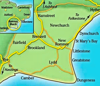
Romney Marsh
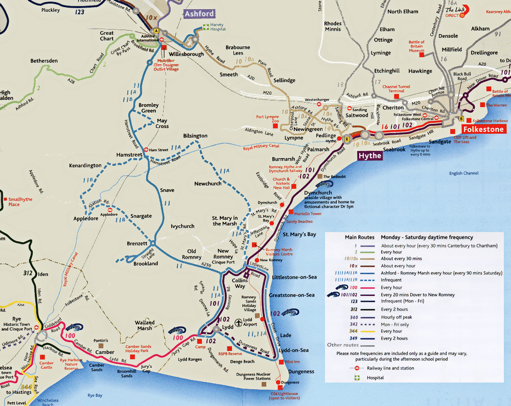
The coastal area of the Marsh from Hythe to Dungeness is served by the light railway Romney, Hythe and Dymchurch Railway (RH&DR), with stations at Hythe, Dymchurch, St Mary's Bay, Romney Warren, New Romney, Romney Sands and Dungeness.
see Romney, Hythe & Dymchurch Railway
 There are regular buses, known as the Wave route, that serve the areas on the A259 coast road that runs from Hastings in East Sussex to Dover.
The Wave has 12 new state-of-the-art vehicles featuring free WiFi and USB charging points for customers were introduced in January 2018.
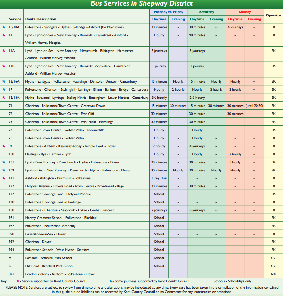
- Routes 100 and 101 run from Lydd through New Romney and then follows the A259 to Folkestone and Dover.
- Route 102 runs from Lydd, through Lydd-on-Sea, Greatstone and Littlestone, before continuing to New Romney and then following the A259 to Folkestone and Dover.
Some of the villages on the Marsh have an infrequent service, served by Routes 11, 11A and 11B, which run to/from New Romney, through the Marsh to/from Ashford.
See Bus Routes Map and Bus Services in Shepway.
You can find out all bus times in Shepway from the Stagecoach Bus Company website.
Romney Marsh is well served by taxis. Please see a full list on our Directory pages.
They are several Council car parks in the area. The map below shows the locations and details about car parks.
Most council car parks are pay and display between 8am and 6pm daily. It's usually free to park outside these times.
There are also car parks on Dungeness and Lydd-on-Sea. 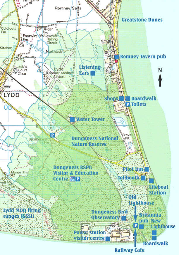 Map.
Map.
There are two car parks in New Romney, one in Church Road and a second in West Street with electric car charging available. ![]() Map
Map
There is free parking for coaches at the Dymchurch Central car park in Orgarswick Avenue. ![]() TN29 0PP.
TN29 0PP.
Ways to pay
All pay and display ticket machines accept 5p, 10p, 20p, 50p, £1 and £2 coins; they don't give change. You can also pay via the RingGo app using a credit or debit card, and
pay over the phone using a credit or debit card, following the instructions on the pay and display machine.
map courtesy of Folkestone & Hythe District Council
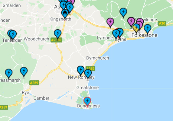
Electric Vehicle Charging Points ![]() Charging Point Plans for Folkestone & Hythe District as at February 2022
Charging Point Plans for Folkestone & Hythe District as at February 2022
More and more businesses and individuals are switching to electric cars, with charging points becoming commonplace in our public car parks and around our amenities. This allows residents of your town and visitors to charge their electric vehicles easily, quickly and safely.
A charging point is a specialist piece of electrical equipment that can be used to recharge your electric vehicle. EV Chargers can essentially be grouped into two types; those that supply alternating current (AC) to the vehicle, and those that ‘rectify’ AC to provide direct current (DC).
The speed with which an EV can be fully recharged is dependent on three factors; the charger type (max power available), the model specification, and the battery capacity of the EV. EV Chargers can be defined by their maximum power rating – Slow (3kW), Fast (7-22kW) and Rapid (50kW+) – the charger type indicates how quickly an EV could charge. However, some electric vehicles are limited in how quickly they can recharge due to the specification of the onboard charger. For example, an EV with a 3kW on-board charger connected to a 7kW charging point can only charge at 3kW.
To complicate matters, if an EV has a large capacity battery, this inevitably will take longer to charge even if the power (rate) is high. In general, EVs with relatively long ranges will have larger battery capacities and therefore take longer to recharge on a particular charging point.
While only an indication, for an average EV, typical recharge times are as follows:
- Slow AC Charging 3kW (16A) : 6-8 hours, best suited for overnight charging;
- Fast AC Charging 7kW (32A) : 3-4 hours; typical charging unit for the home
- Rapid AC Charging 43kW (190A): 45 mins
- Rapid DC Charging 50kW: 30 mins; which are able to provide an 80% charge in around 30 minutes
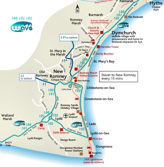
Charging Points on Romney Marsh
The number of public charging points currently available on Romney Marsh and its surrounding area is fairly limited.
The map on the right shows those that exist as at March 2020.
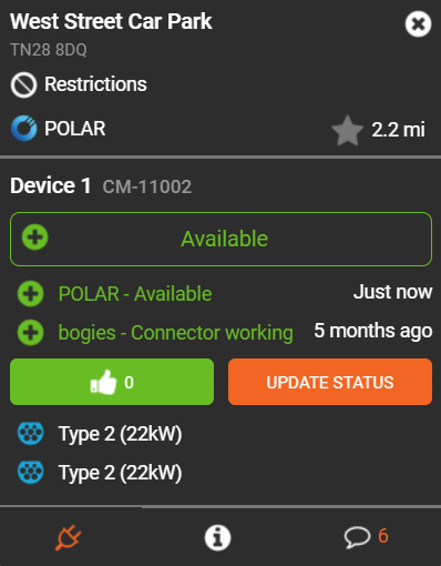
You can find out the up to date position re charging points and the details thereof on the Zap-Map website. Just enter the postcode, town or village of your chosen location on the Zap-Map to see all the charging points in that area.
Clicking on the location icon brings up full information about that particular charging point. See image on the far right.
The Zap-Map website also provides the ability to plan your longer electric car journeys.
Click on the map to enlarge and get more information
NB
Folkestone and Hythe District Council (F&HDC) have announced (29 October 2021) a further 94 electric vehicle (EV) charging points are to be installed in district car parks as part of the council's pledge to drive down its carbon footprint. F&HDC's six existing off-street charging points will be replaced and all will be installed by Connected Kerb, one of the UK's biggest charging point providers. A total of 23 charging points provided by commercial businesses are already in place.
There will be a minimum of four EV charging points in at least 25 of the district's 27 car parks (unfortunately, some car parks are not suitable), offering a mixture of fast 7Kwh, 22kw and rapid 50Kwh, depending on the location. Installation work will start early in 2022. A total of 600 points will be installed across Kent over the next two years, with districts applying for 75 per cent funding through KCC and Connected Kerb funding the remaining 25 per cent.

