
History of Romney Marsh - Origins and Beginning

As the Ice Age ended a great thaw began. Vast quantities of flint nodules, released from the chalk of southern England, were carried by flood waters down to the bed of what became the English Channel, ending up as shingle. Sea levels rose dramatically until the whole area became a great sandy bay covering the whole area, with rivers flowing into it from surrounding valleys.
6,000 years ago, three great changes took place triggering the formation of the Marsh.
- Firstly, the shingle deposited on the channel bed, as the Ice Age ended, started to build up, caused by longshore drift, as a barrier at Dungeness and northwards as far as Dymchurch.
- Secondly, this shingle barrier created a large lagoon behind it to the east, which gradually became mudflats.
- Finally, the three river valleys, the Rivers Rother, Tillingham and Brede, flowing into the lagoons from the Weald high ground left deposits, creating swamps and vegetation.
People used Romney Marsh at least as far back as 2,000 BC. But by c1000BC and after, the sea level started to rise faster than the Marsh was building up.
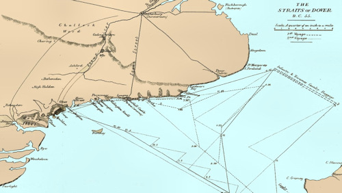
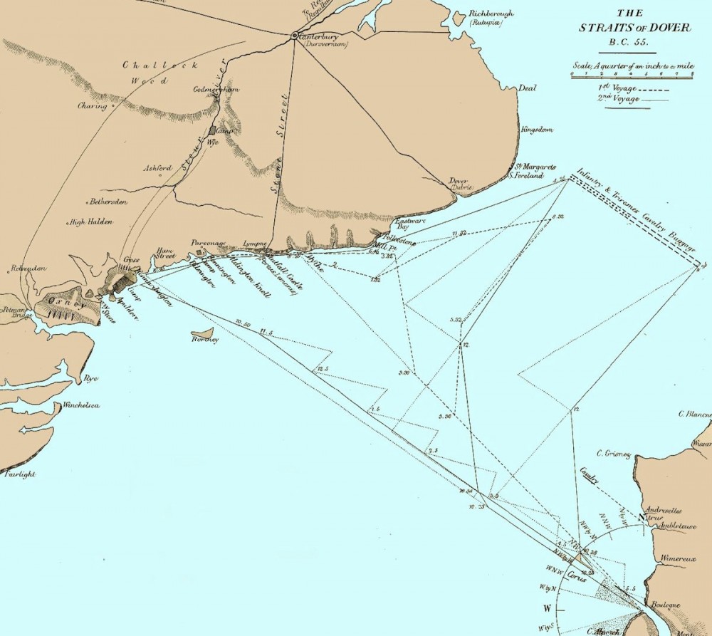
Roman Map Showing the Coastline in 55BC (larger map)
The Romney Marsh had been gradually built up over the centuries. The first portion of the area reclaimed was an island, on which the town of Old Romney now stands; and embankments were extended southward as far as New Romney, where an accumulation of beach took place, forming a natural barrier against further encroachments of the sea at that point.
The land was very marshy and not a very nice place to live. The locals were peasants grazing sheep and cattle on the marsh as it was too wet to grow crops, with malaria prevalent.
The old town of Lydd originally stood upon another island, as did Ivychurch, Old Winchelsea, and Guildford; the sea sweeping around them and rising far inland at every tide.
Burmarsh, and the districts thereabout, were reclaimed at a more recent period, and by degrees the islands disappeared, the sea was shut out, and the whole became firm land.
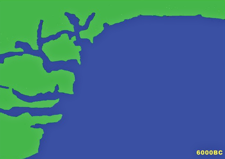
The coastline in 6000BC
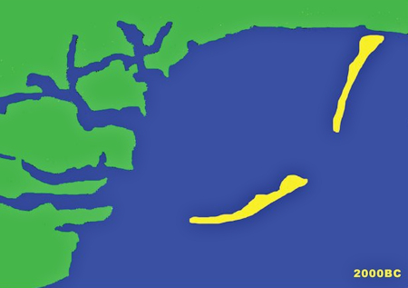
The coastline in 2000BC
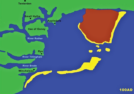 The coastline in 100AD
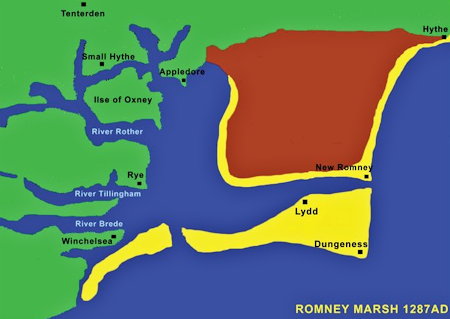 The coastline in 1287, year of the Great Storm
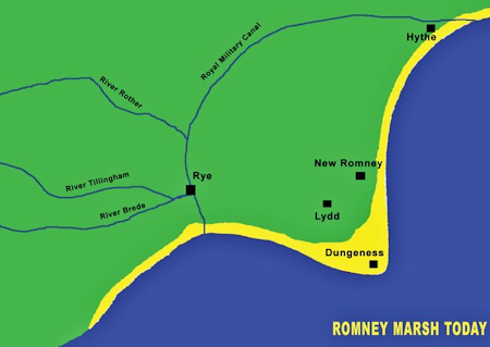
Coastline today
Large additions were made to it from time to time by the deposits of shingle along the coast, which left several towns, formerly important seaports, stranded upon the beach far inland. Thus the ancient Roman port at Lymne, past which the Limen or Rother is supposed originally to have flowed, is left high and dry more than three miles from the sea, and sheep now graze where formerly the galleys of the Romans rode.
Old Romney, past which the Rother afterwards flowed, was one of the ancient ports of the district, but it is now about two miles from the sea.
The marshmen followed up the receding waters and founded the town of New Romney, which also became a Cinque Port. However, a storm (see Great Storm of 1287) that occurred in the reign of Edward I so blocked up the estuary of the River Rother with shingle, at the same time breaching the wall, that the river took a new course, and flowed thenceforward by Rye into the sea; and the port of New Romney became lost.
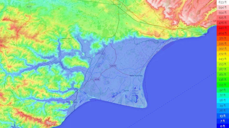
Thus, the history of Romney Marsh is essentially the story of the reclamation of land from the sea, the ongoing battle to drain it and to keep the sea from reclaiming it back.
![]() Kent - Anglo-Saxon Kingdom c500AD to c900AD
Kent - Anglo-Saxon Kingdom c500AD to c900AD
Throughout the centuries all this was happening, life on the Marsh was centred around sheep, smuggling, and defending it from invasion.
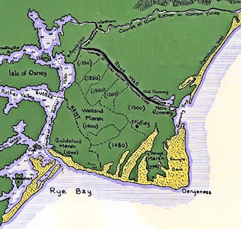
The Gradual Build Up of Romney Marsh

