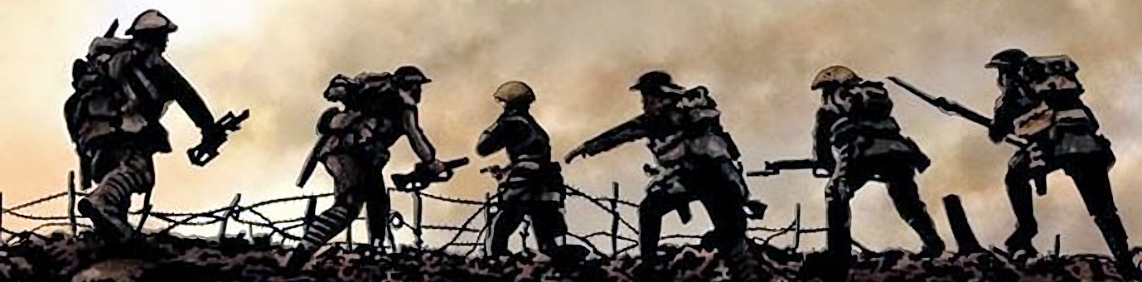
World War Two
This Invasion Coast was none more so vulnerable than in the World War Two
Given this, the Romney Marsh played a significant role in the defence of England, with its Advanced Landing Grounds, PLUTO and much more.
![]() Royal Military Canal
Royal Military Canal
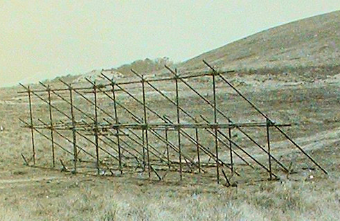
![]() Sound Mirrors
Sound Mirrors
Crashed Plane Memorials
![]() Polish Memorial Dungeness
Polish Memorial Dungeness
![]() US Bomber Crash Greatstone
US Bomber Crash Greatstone
![]() Johnson's Corner Snave
Johnson's Corner Snave

World War Two
World War Two, also called the Second World War, was a conflict that involved virtually every part of the world during the years 1939–45. The principal belligerents were the Axis powers—Germany, Italy, and Japan—and the Allies—France, Great Britain, the United States, the Soviet Union, and, to a lesser extent, China.
The war was in many respects a continuation, after an uneasy 20-year hiatus, of the disputes left unsettled by World War I. World War Two started on September 1, 1939, when Germany invaded Poland from the west; two days later, France and Britain declared war on Germany, beginning World War II on September 17.
The 40,000,000–50,000,000 deaths incurred in World War II make it the bloodiest conflict, as well as the largest war, in history.
In 1940 Germany planned to invade Britain, their Operation Sea Lion.
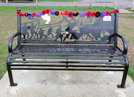
WW2 Memorial Seat at Littlestone
Defending Romney Marsh
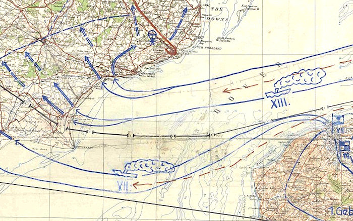
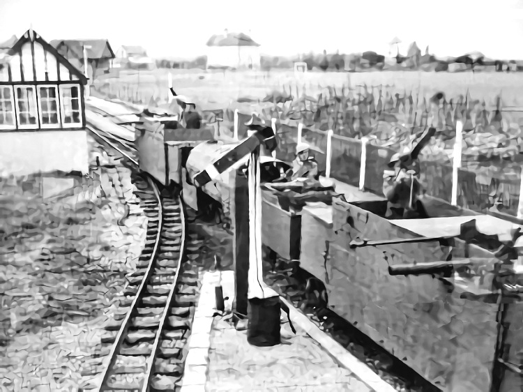
Germany's Operation Sea Lion plan included crossing the flat marsh during an invasion across the English Channel. The government had plans to flood the area to prevent troops and equipment from crossing the area. Thousands of concrete pillboxes were built in Kent; 6,500 of the crumbling structures remain standing to this day. The ancient Royal Military Canal was well guarded with troops, pillboxes, and barbed wire. Training was provided in the area for the secret Auxiliary Units, men who would be deployed in case of an invasion. Four Advanced Landing Ground airstrips were built on Romney Marsh in 1942, for use by fighters and light bombers; these were used for flights in 1944 against the German Flying bombs. The miniature Romney, Hythe and Dymchurch Railway was used by the government to run armoured trains during the construction of Operation Pluto, known as the Pipe Line Under The Ocean. It was to pass under the English Channel and was intended to supply fuel to the Allied forces that would be involved in Operation Overlord (the 1944 invasion of Normandy).
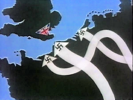
German map of their planned invasion in 1940 larger map
Any German invasion of Britain would have to involve the landing of troops and equipment somewhere on the coast, and one of the most vulnerable areas was Romney Marsh, the planned invasion site of Operation Sea Lion.
The German invasion maps, see right, clearly showed the Romney Marsh as the main area for their planned invasion of Britain in 1940.
Operation Sealion was Hitler’s last big obstacle to own the whole of Europe since Britain was the only country standing between him and the total dominance of Europe. The Fuhrer signed the official document authorizing the Operation Sealion in June of 1940. However Hitler met his match in the Battle of Britain when Royal Air Force defended its territory with unmatched bravery and paramount professionalism.
In the German invasion plan, codenamed Operation Sea Lion, the paratroopers of the 7th Flieger-Division were tasked with a parachute landing to secure crossing points across the Royal Military Canal on the first day of the invasion.
The resistance was unexpected and robust; RAF’s Hurricanes and Spitfires fought gallantly and pushed Luftwaffe where they came from. Not for a single day did RAF allow Luftwaffe to claim superiority over British skies.
Despite the fact that these maps depict a very casual approach towards a certain land invasion of Britain, the RAF’s response and sacrifices to win the Battle of Britain successfully restricted Hitler’s dream of executing Sealion on the papers.
Emergency Coastal Batteries were constructed to protect the most likely landing places. They were fitted with whatever guns were available, which mainly came from naval vessels scrapped since the end of the First World War.
Auxiliary Units or GHQ Auxiliary Units were specially trained, highly secret units created with the aim of resisting the expected occupation of the United Kingdom by Nazi Germany.
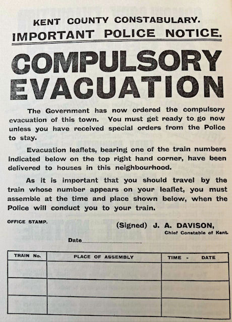
Compulsory Evacuation Notice c1940
Beaches were blocked with entanglements of barbed wire, usually in the form of three coils of concertina wire fixed by metal posts, or a simple fence of straight wires supported on waist-high posts.The wire would also demarcate extensive minefields, with both anti-tank and anti-personnel mines on and behind the beaches. On many of the more remote beaches this combination of wire and mines represented the full extent of the passive defences.
Portions of the Romney Marsh were flooded and there were plans to flood more of the Marsh if the invasion were to materialise.
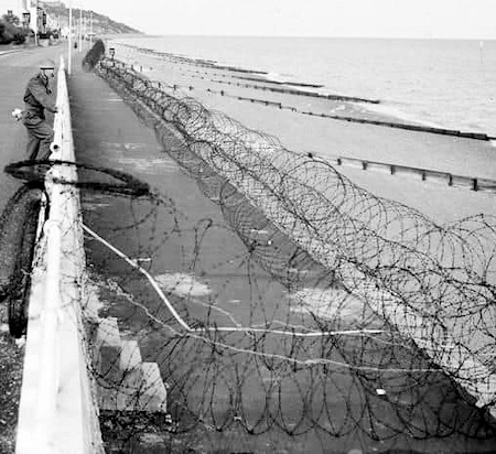
Barbed Wire Along the Coast 1940
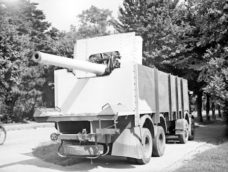
Mobile 4 ins Gun Littlestone in July 1940
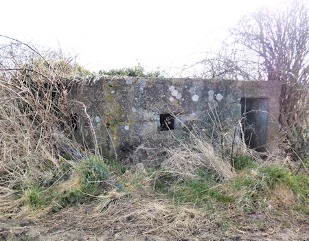
Pillboxes are concrete dug-in guard posts, normally equipped with loopholes through which to fire weapons. About 28,000 pillboxes and other hardened field fortifications were constructed in England in 1940 as part of the British anti-invasion preparations of the Second World War. About 6,500 of these structures still survive, many on Romney Marsh.
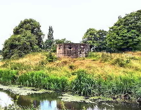
Pillbox nr Appledore
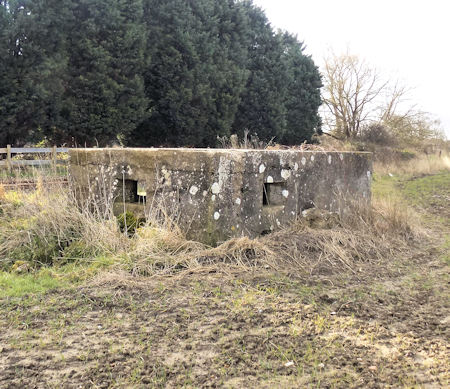
 Pillbox 1 at St Mary's Bay
Pillbox 2 at St Mary's Bay
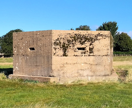
Pillbox at New Romney
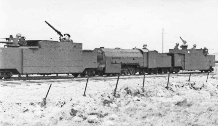
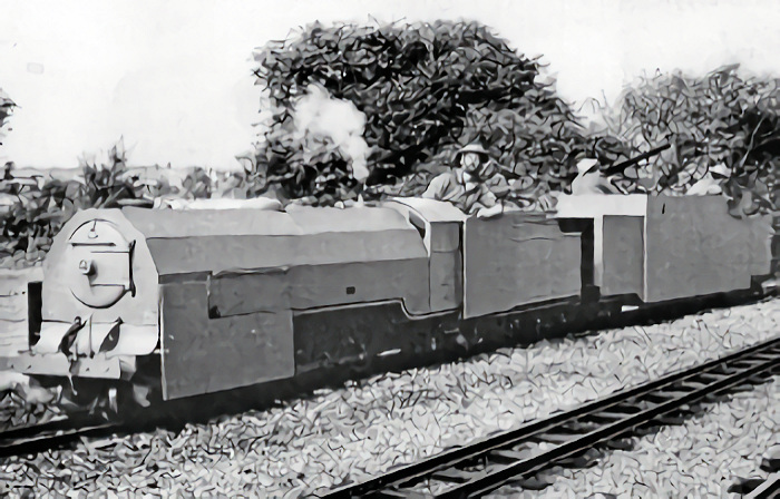
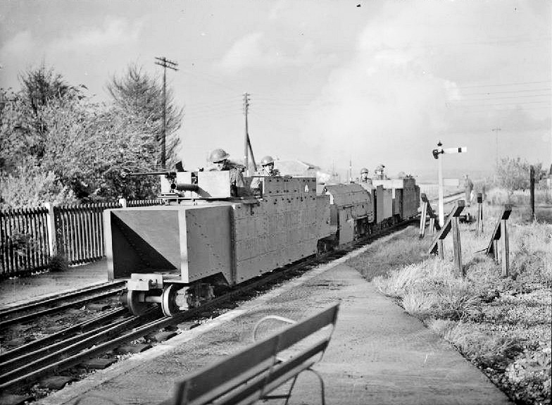
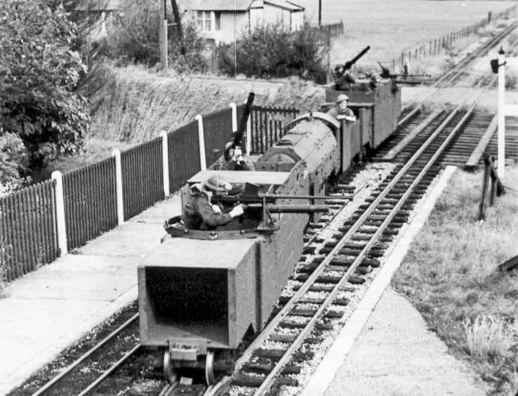
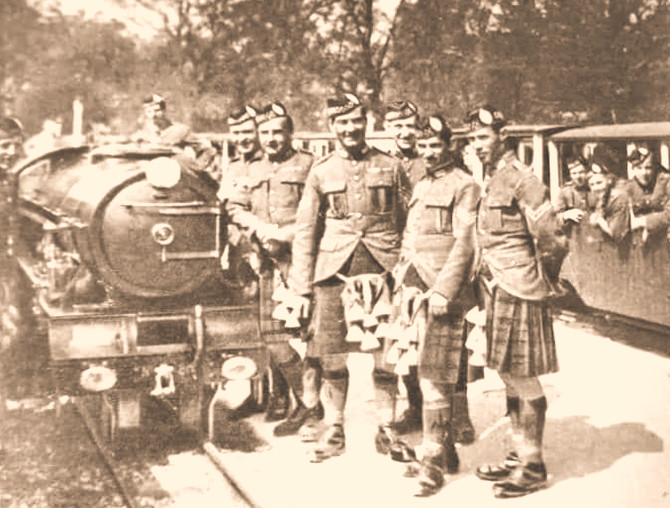
Romney Hythe & Dymchurch Railway (RH&DR)
The war years took their toll of the Romney Hythe & Dymchurch Railway, the miniature railway being requisitioned by the War Department. They even created the only miniature armoured train in the world. The RH&D armoured train carried Lewis guns and Boys anti-tank guns and was credited with shooting down 3 German planes.
The railway line was used extensively during the building of PLUTO (Pipe Line Under The Ocean) which fuelled the Allied invasion force.
A spur line to the Sound Mirrors was built off the RH&DR, known at the time as the War Department Branch, which was used to transport men, equipment and building materials to the mirrors site. The branch line was closed in 1951.
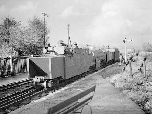
Armoured train on the RH&DR
Photo Gallery of the Armoured Train scroll right and left and click on a picture to see it enlarged in a slideshow


Auxiliary Units
Auxiliary Units or GHQ Auxiliary Units were specially trained, highly secret units created by the United Kingdom government during the Second World War, with the aim of resisting the expected occupation of the United Kingdom by Nazi Germany.
More about Auxiliary Units
Many of the high buildings on the coast of Romney Marsh coast were used as observation posts by the Military and the Observer Corps during the Second World War. They were looking out for any signs of enemy activity but their main function was observing and identifying aircraft and the Flying Bombs as they crossed the Romney Marsh coastline.
These Romney Marsh buildings included the tower of All Saints Church in Lydd, at 132 feet one of the tallest church towers in Kent. The military also used the 120ft Water Tower at Littlestone and Martello Tower No. 24 at Dymchurch as lookout posts.
Entrance to Auxiliary Unit Operational Base Today
The Sound Mirrors at Greatstone are large concrete structures built between 1928-30 as an early warning system for Britain to detect enemy aircraft.
More about Sound Mirrors
The Royal Military Canal was created as a major military defence against Napoleon in the early 19th century. During the early stages of the Second World War, during preparations for a threatened German invasion, the canal was manned by 31st Independent Brigade Group, who fortified each salient with a concrete pillbox and barbed wire entanglements; numerous pillboxes survive today.
Find out more
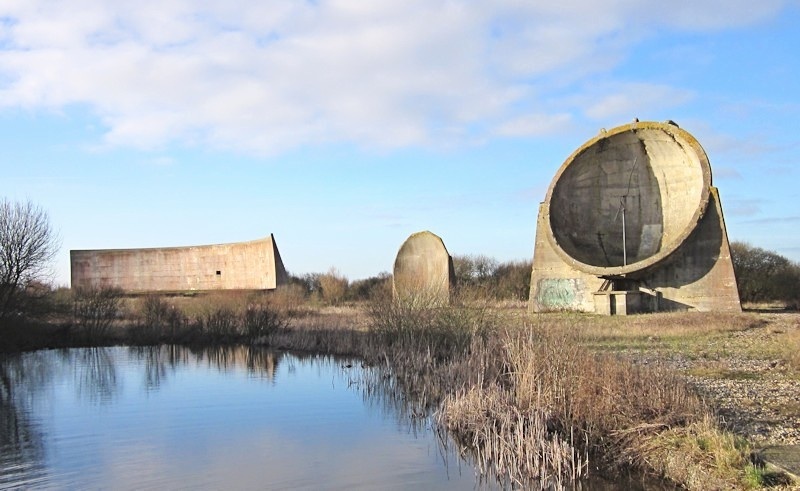
Sound Mirrors
Admiralty Scaffolding, also known as Obstacle Z.1 or sometimes simply given as beach scaffolding or anti-tank scaffolding, was a British design of anti-tank and anti-boat obstacles made of tubular steel. It was widely deployed on beaches of southern England, eastern England and the southwestern peninsula during the invasion crisis of 1940-1941. Scaffolding was also used, though more sparingly, inland.
The photo below right shows the remains in 2018, revealed at low tide, of such scaffolding on the beach just south of Dymchurch.
Of a number of similar designs, by far the most common was designated obstacle Z.1. This design comprised upright tubes 9 feet (2.7 m) high and 4 feet 10 inches (1.5 m) apart, these were connected by up to four horizontal tubes. Each upright was braced by a pair of diagonal tubes, at about 45°, to the rear.[6] 20-foot (6 m) wide sections were preassembled and then carried to the sea to be placed in position at the half tide mark as an obstacle to boats.
![]() Reference and more information
Reference and more information
Section of Admiralty scaffolding prepared for testing
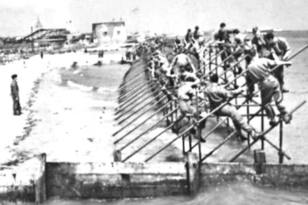
Erecting Anti-Tank Scaffolding on the Beach
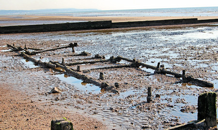
Remains of scaffolding on the beach just south of Dymchurch
Tank Traps (Dragon's teeth) are square-pyramidal fortifications of reinforced concrete first used during the Second World War to impede the movement of tanks and mechanised infantry.
Vehicles cannot drive through Tank Traps, and must instead seek another way around the obstacle to reach the destination behind it.
The idea was to slow down and channel tanks into zones where they could easily be disposed of by anti-tank weapons.
The picture on the right shows tank traps in a field off the B2080 between Snargate and Brenzett
![]() Reference and more information
Reference and more information
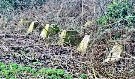
Tank Traps
Examples of Symbols
 Anti-Aircraft Gun
 Anti-Tank Obstacle
 Beach Scaffolding
 Coastal Battery
 Mines
Mines
 Pillbox
PLUTO
The Pipe Line Under the Ocean (PLUTO) ran from Dungeness and Greatstone under the English Channel to the French coast to supply fuel to the allied D Day invasion army in the second world war.
More about PLUTO
The V-1 flying bomb, also known as the Buzz Bomb or Doodlebug, was an early pulse-jet-powered predecessor of the cruise missiles developed by the German Luftwaffe during the Second World War. The V1 was first launched against Britain in June 1944, just one week after D-Day, with one of the first being sited by the Royal Observer Corps crew manning their post in Dymchurch.
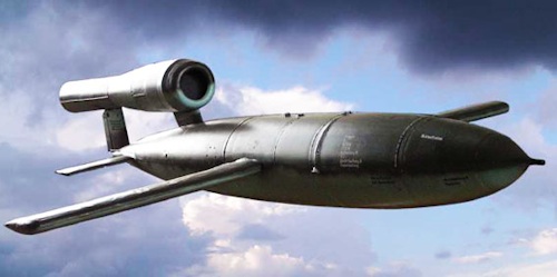
V1 Flying Bomb
The Flying Bombs traveled at 360 miles an hour (a mile in 10 seconds), a bit slower than the fighter of 1944 - typically reaching their target about 22-25 minutes later.
At its peak, more than one hundred V1s a day were fired at south-east England, 9,521 in total, decreasing in number as sites were overrun until October 1944, when the last V1 site in range of Britain was overrun by Allied forces.
Overall, the main onslaught by ‘flying bombs’ ended about 5½ months after that first ranging attack in June 1944. In all, 8,025 V1s were launched against the UK and, of those, 4,261 were intercepted and shot down.
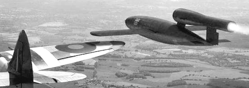
WW2 fighter pilots used their airborne skills to tip V1 Flying Bombs out of the sky to bring them down
There were 3 forms of defense against V1s - fighter aircraft, anti-aircraft guns, and balloons. Given one of the main routes of the flying bombs was over the Romney Marsh coast, many of the fighter aircraft were based at one of the four Advanced Landing Grounds on Romney Marsh and shooting the flying bombs down over the sea.
Find out more on our page about the Royal Observer Corps
![]() Reference and more information
Reference and more information
Read about the Second World War on the Marsh in Romney Marsh at War by Edward Carpenter.
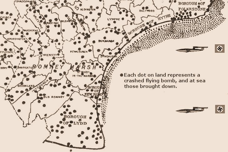
Flying bombs crashed on land and brought down over the sea, 1944


