
New Romney History

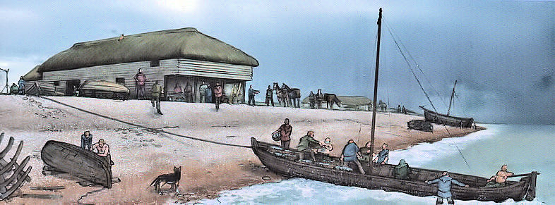
Beach at Medieval New Romney (Ack. 40)
New Romney was founded on a shingle spur which probably began to form during the late neolithic period (c6000 BC to c2500BC). Between c. 5000 BC and AD 500 a long shingle spit, probably caused by easterly longshore drift, was deposited between Hastings and Hythe, resulting in a barrier behind which a salt marsh developed through silting by waterways from the Weald. The waterways finally merged to form the river Limen (later called the Rother).
Sometime cAD 450-700 the shingle barrier was breached by the sea, creating a wide marine inlet and an outlet for the river Limen between Dymchurch and Lydd. By the mid-eighth century a shingle spur on the north-eastern side of this new inlet was occupied by a small settlement consisting of fishermen’s huts and an early church, that of St Martin
(For more detail please read Kent Historic Towns Survey NEW ROMNEY Archaeological Assessment Document December 2004)
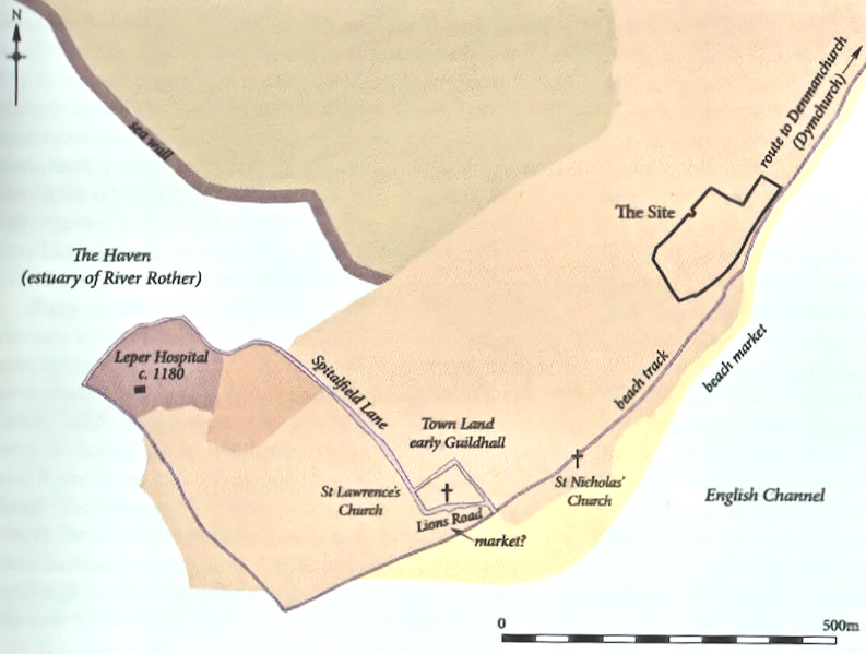
New Romney, one of the original five Cinque Ports, was originally a port town at the mouth of the River Rother, with the sea close to St Nicholas Church and its harbour to the south west of the town. It is now more than a mile from the sea.
The settlement at New Romney was almost certainly developed as early as cAD 700 when a small group of fishermen’s houses and a church (St Martin) were established on a shingle spur, with a shelving beach and good anchorage developing into a port.
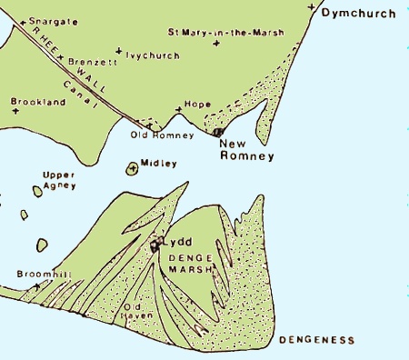
Romney Marsh c1200
In Saxon times (cAD 410 to AD 1066) the port consisted of a market with shallow draught trading and fishing that could easily be floated on and off the beach. Subsequently in the river estuary (now known as the Rother) an anchorage was used for larger vessels.
A new planned town was laid out sometime between AD 960 and AD 1000, probably with a grid pattern of streets and tenements around an early road from Ashford to the sea, on the line of an early road between Hythe and Old Romney. The High Street eventually developed along this route, with a market place in the High Street and a harbour and wharf to the south west at Old Romney.
There were also three parish churches, St Martin, St Lawrence and St Nicholas, two hospitals, and a Cistercian Priory.
![]() Lost Churches of New Romney
Lost Churches of New Romney
The name Romney is derived from Old English 'at the spacious, or wide, river' recorded in AD 895 AD as Rumenea, and in a charter dated AD 914 as Rumenesea. This led to the derivations Romenel or Romenal and Romney.
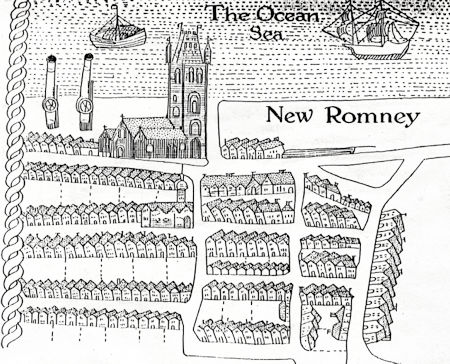
The Port of New Romney c1200
This appears to have been an early name for Romney Marsh, whose inhabitants are referred to in AD 774 as Merscuuare and in AD 796 as Merscware (Old English merscware: marsh people). Their territory is described in AD 811 as regio Merscuuariorum (region of the Marsh People); and earlier, in 697, there appears here the name Ruminingseta: 'fold of the dwellers by the spacious river' and Rumeneia
Rumeneia was the name of the river we know as the Rother, which used to flow into sea at New Romney but now flows out through Rye. It would appear that this river had different names in different parts of it, which is not unusual and happens elsewhere in the country. Near the source or spring head, it was likely called the Rother. Lower down and along the branch which flowed out to the sea at the Roman port Portus Lemanis near the Roman fort at Stutfall, the Limen and as the Rumeneia near New Romney. Hence the name Romney.
The present place names appear as Rumney, Old Rumney in 1575, and as Romney, Old Romney in 1610.
Romney Marsh was known by the English Saxons first as Merscwarum and then, in c795, as Merscware. It is not certain when it first became know as Rommene, or Romney. There was mention of this name in 895 related with land owned by the Archbishop of Canterbury near the river called Rumeneia.
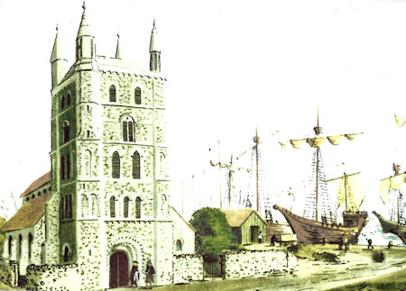
New Romney c1100 (Ack. 41)
Discover more about the town of New Romney and its unique Norman history by following
a ![]() Norman Walk in New Romney.
Norman Walk in New Romney.
Shakespeare in New Romney
William Shakespeare, the English poet, playwright, and actor, visited New Romney at least three times between 1609 and 1615 to perform his plays.
From the 1500s, licensed actors were organised into permanent companies and in 1603 Shakespeares group was promoted to be the King's players. Formerly known as The Lord Chamberlain's Men during the reign of Queen Elizabeth I, it became The King's Men in 1603 when King James I ascended the throne and became the company's patron.
It was as one of the leaders of these 'King's Men' that Shakespeare come to New Romney, with the company including Richard Burbage, the top tragic actor of the time.
Find out more
William Webb's Map of New Romney in 1614
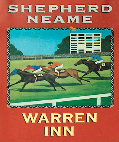
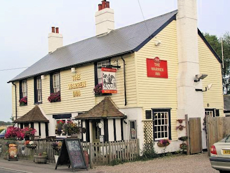
In the late 1700s there used to be a racecourse which was located to the north of the town somewhere near the Warren Inn pub and the property Warren Lodge. The course was some 2 miles in length. The date of the first meeting was in April 1777 and the final meeting was in August 1810.
The only known evidence of the racecourse is that the sign of the Warren Inn pub is that of a racecourse with racehorses. See pictures right
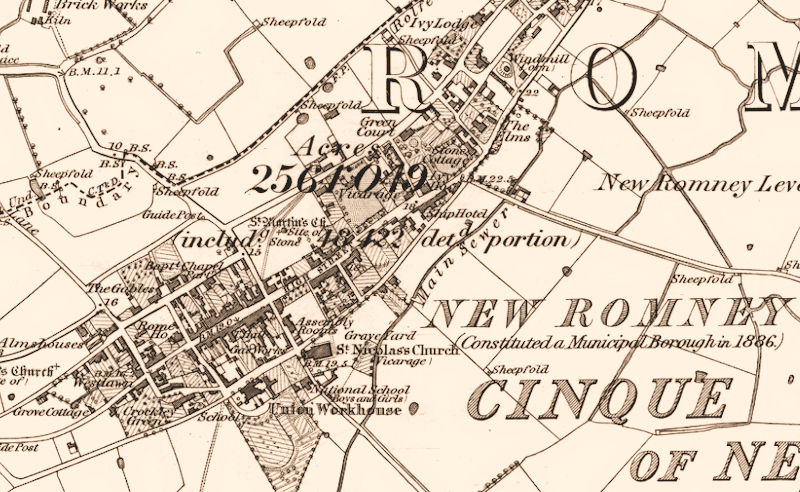
Map of New Romney in 1872
In 1870-72, John Marius Wilson's Imperial Gazetteer of England and Wales described New Romney like this:
ROMNEY (New), a small town, a parish, and a sub-district, in Romney-Marsh district, Kent. The town stands 1½ mile from the coast, 7 S E of Ham-street r. station, and 9 S W of Hythe; was known to the Saxons as Rumenea, and to the Normans as Romenel; had, at Domesday, five parish churches, a hospital, twelve wards, and 156 burgesses; ranked, for some time, as an important one of the cinque ports; lost its harbour, in the time of Edward I., by a great storm which changed the course of the river Rother; is a borough by prescription, and was chartered by Edward III.; sent two members to parliament, till disfranchised by the reform act of 1832; is a seat of county courts, and a polling-place; gives the title of Earl to the family of Marsham; and has a post-office† under Folkestone, a good inn, a market house, an assembly-room, a church, a Wesleyan chapel, a national school, a work-house, alms-houses with £112 a year, other charities £11, and a large stock fair on 21 Aug. ...
The church is mainly Norman, partly early English; consists of a nave, aisles, and chancel, with a loftytower, seen all over the surrounding level; contains apiscina, two brasses, and some ancient monuments; and belonged once to Pontignac abbey in France. A cell of that abbey was once here; a lepers' hospital, or chantry, of the time of Henry II., also was here; but both have been entirely effaced. The parish comprises 2, 276 acres of land, and 643 of water. Rated property, £5, 619. Pop., 1,062. Houses, 205. The property is subdivided. There is a coast-guard station. The living is a vicarage, united with the sinecure rectory of Hope-All Saints, in the diocese of Canterbury. Value, £430. Patron, All Souls College, Oxford.—The sub-district contains alsoten other parishes. Acres, 20, 671. Pop., 2, 882. Houses, 585.

