Invasion Coast
Invaders from the Romans legions, the Anglo-Saxons, the Vikings, the French, and the Germans have all tried.
On a clear day, you can actually see the hazy outline of the French coast from the beaches of Romney Marsh, so it’s no surprise that this iconic stretch of the Kent coastline has been the site of conflict for millennia.
Over the centuries that the Kent coast has been at risk of invasion, much was done to protect the area by various means, including a chain of defences comprising Martello Towers, Forts, Redoubts and the Royal Military Canal. Almost all of which you can still visit and see today.
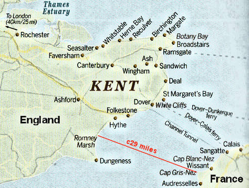
The beaches at Dymchurch, Greatstone, and Dungeness are just 29 miles away from the French Coast (Cap Gris-Nez), just about 4 hours sailing time. London is twice as far, being over 60 miles away.
![]() Advanced Landing Grounds
Advanced Landing Grounds
![]() Anglo-Saxons
Anglo-Saxons
![]() Auxiliary Units
Auxiliary Units
![]() Beacons
Beacons
![]() Cinque Ports
Cinque Ports
![]() Deliberate Flooding of the Marsh
Deliberate Flooding of the Marsh
![]() Defences, World War Two
Defences, World War Two
![]() Dungeness Batteries
Dungeness Batteries
![]() Dymchuch Redoubt
Dymchuch Redoubt
![]() The French
The French
![]() Flying Bombs
Flying Bombs
![]() The Germans
The Germans
![]() Invasion Coast Walk
Invasion Coast Walk
![]() Local Resistance
Local Resistance
![]() Martello Towers
Martello Towers
![]() Mulberry Harbour
Mulberry Harbour
![]() Napoleonic Wars
Napoleonic Wars
![]() The Normans
The Normans
![]() Operation Sea Lion
Operation Sea Lion
![]() Pillboxes
Pillboxes
![]() PLUTO
PLUTO
![]() RH&D Railway
RH&D Railway
![]() The Romans
The Romans
![]() Royal Military Canal
Royal Military Canal
![]() Second World War
Second World War
![]() Sound Mirrors
Sound Mirrors
![]() The Spanish
The Spanish
![]() The Vikings
The Vikings
Invasions Timeline
cAD 49 Romans
c450 Anglo-Saxons
841-892 Vikings
1066 Normans
1155-1200s Cinque Ports
1588 Spanish
1803-1815 French
1939-1945 Germans

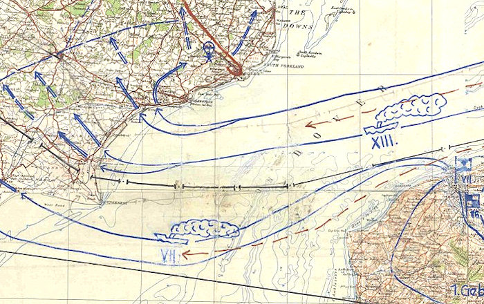
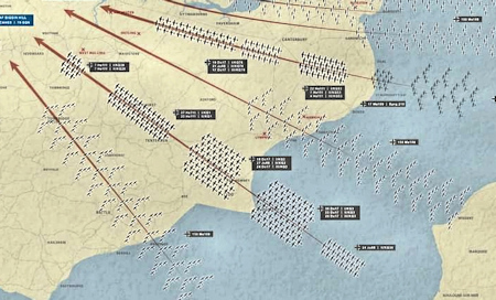
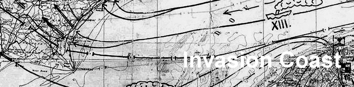
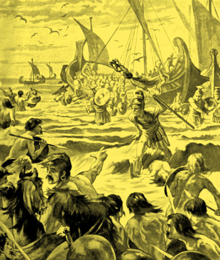
German attempted invasion by air in September 1940
(Battle of Britain Archive - 7 September 1940)
◄ German map of their planned invasion in 1940 more information

The Romney Marsh covers an area of about 100 square miles and its coastline extends south from Hythe round Dungeness Point, some 20 miles of flat and easy accessible coastline.
The closeness of Romney Marsh to the continent, its flat shores and hinterland and easy accessible beaches, has meant that the Marsh has been in the front line whenever invasion has threatened, particularly from across the English Channel.
Indeed, invaders from Julius Caesar’s Roman legions, the Anglo-Saxons, the Vikings and Napoleon’s warships to First World War bombers and Hitler’s planned invasion in 1940, all tried with some succeeding.
Over hundreds of years, given this vulnerability to invasion, many forms of defending Romney Marsh, and thus the rest of Britain, were put in place. Many of these remain today on the Marsh.
The Romans had invaded Britain from France in about AD 43 and had built 10 forts around the Kent coast to protect them from Saxon invaders.
Julius Caesar’s invasion of Britain was launched from the sandy shores of Pegwell Bay on the most easterly tip of Kent, according to the latest evidence unearthed by archaeologists.
The Romans worked the Marsh for salt at Dymchurch, Lydd, and St Mary's Bay. There are reports that Roman artefacts were found in the building of the Dymchurch Wall. Find out more
Remains of Roman pottery have also been found in Lydd,
The remains of a fort, Stutfall Castle (see map), built by the Romans to protect its port Portus Lemanis and local area from attack by the Anglo-Saxons, can be found near Lympne over-looking what became Romney Marsh.
![]() Find out more about Stutfall Castle
Find out more about Stutfall Castle
![]() BBC Article 'Everything you wanted to know about Roman Britain'
BBC Article 'Everything you wanted to know about Roman Britain'
Landing of the Romans on the Coast of Kent
The Roman legions abandoned Britain in the early fifth century. According to the Anglo-Saxon Chronicle, Vortigern, the British ruler in Kent invited the mercenaries Hengist and Horsa to defend his principality from outside attack. They are said to have landed at Ebbsfleet near Ramsgate in 448 or 449 AD.
By the end of the fifth century, the Saxon kingdom of Kent had been firmly established. Under its king, Aethelbert (c.560-616), Kent became one of the most advanced Saxon kingdoms in England.
It was to Kent that Pope Gregory sent his missionaries under Augustine to begin their preaching of the gospel of Christianity to the English people, although the religion was already established.
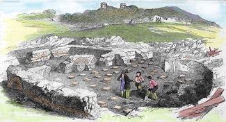
Excavation of Stutfall Castle as reported in an
issue of the 'Illustrated London News' of 1850
By the end of the fifth century, the Saxon kingdom of Kent had been firmly established. Under its king, Aethelbert (c.560-616), Kent became one of the most advanced Saxon kingdoms in England. It was to Kent that Pope Gregory sent his missionaries under Augustine to begin their preaching of the gospel of Christianity to the English people, although the religion was already established. They were well received and instead of moving on to London as they had planned, they established their first cathedral at Canterbury. Romney Marsh has two churches named after Augustine; St Augustine in Brookland and in Snave.
The Anglo-Saxons were Germanic Tribes from northern Europe who raided the shores of south and east England in the fourth century AD, but they were beaten back by the Romans. At the beginning of the 5th century, the Romans left Britain. They had not trained the British to defend themselves and so the next time the Saxons tried to invade Britain they succeeded.
The Anglo-Saxons founded the kingdom of Kent in the 5th century. They ruled in England for about 500 years, ending at about the time of the Norman invasion. However, unlike the Romans, the Anglo-Saxons never 'went home'; many people living in Britain today have Anglo-Saxon ancestors. The name England even comes from the Saxon word 'Angle-Land’.
Find out more about Anglo-Saxon Kent
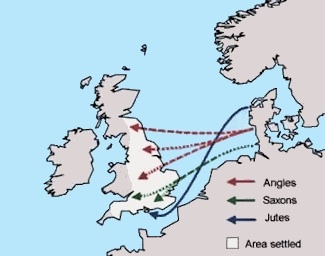
Routes taken into Britain, by the Angles, Saxons, and Jutes, in the 5th century
In 892 a fleet of 250 Viking ships, with the notable Viking chieftain warrior Haesten at their head, left France and headed for the south coast of Kent, They made its way up the River Rother, which flowed out to the sea at New Romney on Romney Marsh at the time, as far as Appledore. They announced their arrival by storming a nearby fort and then establishing a fortified camp at Appledore. Some 10,000 warriors and their families landed and the soldiers raided the nearby St Rumwold's Church in Bonnington. The chronicles record all those inside were killed.
Having been contained by the army of King Alfred from a postion in middle Kent, the Vikings abandoned their camp in 893 and made their way through the weald of Kent to Essex. They were met by an army led by King Alfred's eldest son Edward and beaten.
The raids continued for another four years with the Vikings establishing camps over the winter months and it was not until 896 did the Vikings finally abandon their attempts at permanent settlement and returned to Northern France.
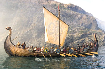
The Vikings
Local legend has it that in1066 William the Conqueror initially attempted to land near New Romney, but was seen off by the hardy locals. The tale has a kernel of truth as it seems that some of William's men did disembark at New Romney by mistake and were rebuffed, but it was a small-scale engagement. Source
It is also said that after the battle of Hastings, William the Conqueror, on his march to London, William heard that the men of a nearby coastal town called Romney were attacking his ships. He immediately ordered a contingent of his soldiers to go and sack the town. With Romney now subdued he could keep his forces within easy reach of his ships and happily continue on his journey.
Romney Marsh Tapestry
Cinque Ports
A Royal Charter of 1155 in the reign of Henry II established the port of New Romney as one of the first Cinque Ports, maintaining ships ready for the Crown in case of need.
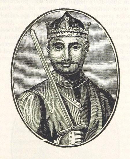
William the Conqueror
The chief obligation laid upon the ports, as a corporate duty, was to provide 57 ships for 15 days' service to the king annually, each port fulfilling a proportion of the whole duty. In return the towns received many privileges.
Lydd became a corporate member of the Cinque Ports in the 13th century as "limb" of New Romney.
Find out more about the Cinque Ports
The Spanish monarch, Philip II (1527-1598), was a devout Catholic. He felt it was his duty to invade and conquer England in order to convert the country back to the Church of Rome. He was also angry that Queen Elizabeth had not punished Sir Francis Drake and other English seadogs for plundering Spanish ships.
In 1588 he ordered the Spanish fleet, or Armada, to sail up the English Channel, collect the army waiting at Calais and transport them across the Channel to Kent.
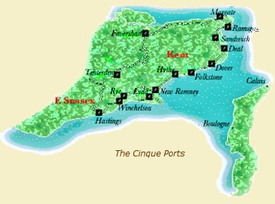
Cinque Ports Map
The Spanish plan was for Philip's Armada of 132 ships carrying 8,000 sailors and 20,000 marines eventually sailed from Spain under the command of the Duke of Medina Sidonia. The plan was to sail to Calais. There they would meet with the Duke of Parma and his 30,000 soldiers. Parma had ordered the construction of flat-bottomed barges that were to be used to transport his troops across the channel in order to invade England. The Armada was to provide protection using their crescent formation with the barges in the centre.
The Spanish soldiers would then land in Kent and march on London where they would be met by an army of 25,000 English Catholics. London would be captured. Elizabeth I was to be removed from the throne and replaced with a Catholic monarch, originally, Mary Queen of Scots.
But the planned invasion never happened. The Armada was intercepted off Plymouth by the English fleet, with Sir Francis Drake as Vice Admiral, and managed to inflict some damage but could not stop it. The Armada anchored off Calais and the English sent in eight fireships which the Spaniards to panic, cut their anchor cables and scatter out to sea to avoid them.
A day of fierce fighting between the two fleets followed called the Battle of the Gravelines, during which the Spanish fleet was blown dangerously close to the shore. Then the wind changed and they sailed northward. Victory for the English followed shortly afterwards when the Spanish decided to give up and return to Spain by sailing north around Scotland.
Reference and more information![]()
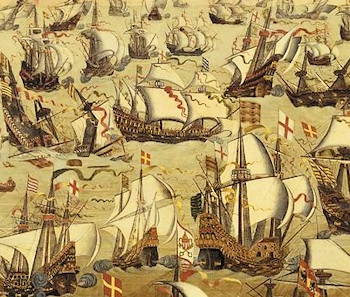
English Ships and the Spanish Armada in 1588
The French
Napoleon Bonaparte (1769 – 1821) was Emperor of the French from 1804 until 1814.
Napoleon dominated European and global affairs for more than a decade while leading France against a series of coalitions in the Napoleonic Wars. He won most of these wars and the vast majority of his battles, building a large empire that ruled over continental Europe before its final collapse in 1815. One of the greatest commanders in history, his wars and campaigns are studied at military schools worldwide.
For some time, and particularly in 1803, Napoleon intended to attack England, concentrating a force of 130,000 men and thousands of barges and small boats along the French coast.
Find out more about Napoleon's plans to invade England.
Due to his success in these wars, often against numerically superior enemies, Napoleon is generally regarded as one of the greatest military commanders of all time, and his campaigns are studied at military academies worldwide. Napoleon waged war against Britain from 1803 to 1815, when he was defeated by Wellington at the Battle of Waterloo. He also remains one of the most celebrated and controversial political figures in human history
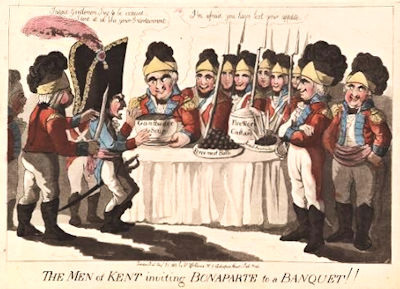
'The Men of Kent inviting Bonaparte to a banquet!!'
Larger Image
Martello Towers
Martello Towers are small defensive forts that were built along the Kent coast to defend Britain against the French in the early 1800s, then under the rule of Emperor Napoleon.
Find out about Martello Towers
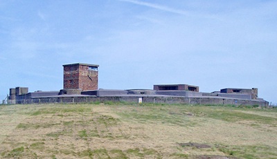
Dungeness Batteries and Redoubt
The four batteries and redoubt at Dungeness and Lydd-on-Sea were part of the defences built along the Kent coast to defend Britain against the French in the early 1800s.
Find out about Dungeness Batteries
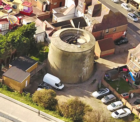
Dymchurch Redoubt
Dymchurch Redoubt was built between 1804 and 1812 to support a chain of 21 Martello Towers that stretched between Hythe in Kent and Rye in Sussex, and to act as a supply depot for them.
More about Dymchurch Redoubt
Martello Tower No.24 at Dymchurch
Royal Military Canal
The Royal Military Canal was built in 1804 to 1809, as a third line of defence against Napoleon, after the British Royal Navy patrolled the English Channel and the line of 74 Martello Towers was built along the south coast.
More about the Royal Military Canal
The Second World War with Hitler's Germany lasted from 1939 to 1945, and during the summer and autumn of 1940 the Battle of Britain fought over Kent was to be Hitler's precursor to invasion.
more about Second World War
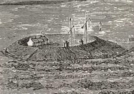
Dungeness Redoubt
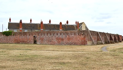
Battery No.2 (Lade Fort) at Lydd-on-Sea
Dymchurch Redoubt
