Storm of 1287
.jpg)
The Great Storm of 1287 (Ack.40)
In the 13th century, a series of storms occurred which had significant effects on the development of Romney Marsh. Storms occurred in 1236, 1250, 1252, 1271, 1287 and 1288 with the disastrous storm in 1287 having the greatest impact.
The River Rother, flowing out to sea at New Romney, had been silting up for many years and this, together with the increase in the size of ships needing deeper water, meant that the storms only added to an already worsening situation for the port at New Romney.
To counter the problem the Rhee Canal was dug from Appledore first to Old Romney and then in 1258 to New Romney. The idea was to divert water from the Rother into the canal, build up a head of water behind a sluice gate at Snargate, and then release it to flush out the harbour at New Romney.
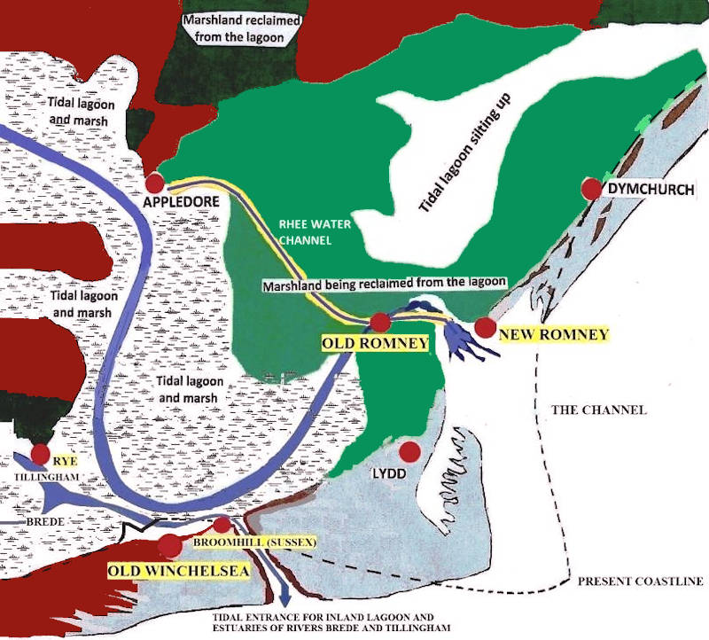
Romney Marsh between 1100 and the Great Storm of 1287 (Ack.57)
Storm of 1287
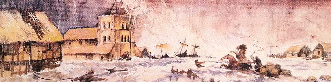
In 1287, a storm hit the southern coast of England with such ferocity that whole areas of coastline were redrawn - towns that had stood by the sea now found themselves landlocked, while others found themselves in possession of a new harbour.
Along the coast from Romney Marsh, the port of Winchelsea was completely destroyed. Old Winchelsea was a substantial town which in the 1260’s reportedly contained 700 houses, two churches and over fifty inns and taverns.
Winchelsea was later rebuilt several miles inland, where it became the first example of town planning in England being built on a grid system familiar to our American friends. Despite its new position Winchelsea still retained its place as a Cinque Port.
Part of the Norman castle and cliff at Hastings crashed into the sea, blocking the harbour forever.
The most dramatic change wrought by the great storm was to the towns of Rye and New Romney. Before the storm, New Romney was a thriving harbour town with the River Rother flowing into the English Channel at this point. Massive quantities of shingle from Dungeness, along with mud and soil, inundated the town, completely filled the harbour and made the harbour un-useable.
The river Rother, which ran through the town, was stopped up by the storm and found a new outlet to the sea at Rye, 15 miles away, a course that the river still takes. In New Romney there is still visible evidence of this extreme event.
The storm silted up the harbour completely and diverted the river away from the town. More or less overnight New Romney became effectively landlocked. So much silt was deposited by the flood that the land level in the town rose by 5 inches.

The Great Storm at New Romney 1287
Artist's impression on the cover of the New Romney Town Trail leaflet
The Rhee Canal was ineffective after the 1287 Storm and fell out of use. Later it become known as the Rhee Wall.
If you visit the parish church you will find that the floor of the church is several inches below street level. The pillars in the church provide further evidence of the flood - the level the water reached can still be seen on them.
By the 14th century, much of the Walland and Denge Marshes had been reclaimed by innings, the process of throwing up an embankment around the sea-marsh and using the low-tide to let it run dry by means of one-way drains set into the new seawall, running off into a network of drainage ditches.
The drainage dykes and ditches, known locally as sewers, drain the water from the farmland and allow it to flow either to the sea via outfalls or is pumped into the Royal Military Canal, eventually also ending up in the sea.
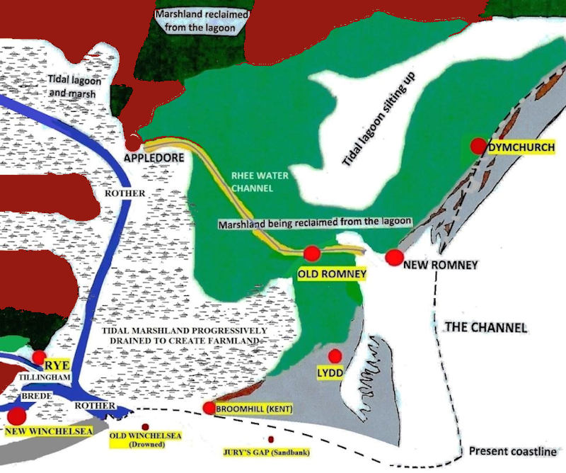
Romney Marsh after the Great Storm of 1287 (Ack.57)

