
Royal Military Canal
The Royal Military Canal was a massive coastal defence work constructed between 1804 and 1809. Its purpose was to separate the expected landing and deployment of Napoleon's troops upon the coast of Romney Marsh and Walland Marsh from the interior of the country. The Government initially considered flooding the Marsh but favoured the canal, which was the idea of Lt. Col. Brown, the Assistant Quartermaster-General.


Royal Military Canal
The Royal Military Canal was created as the third line of defence against the French during the Napoleonic Wars in the early 19th century (see History of The Canal below). The canal is universally recognised as an important component of the counties heritage.
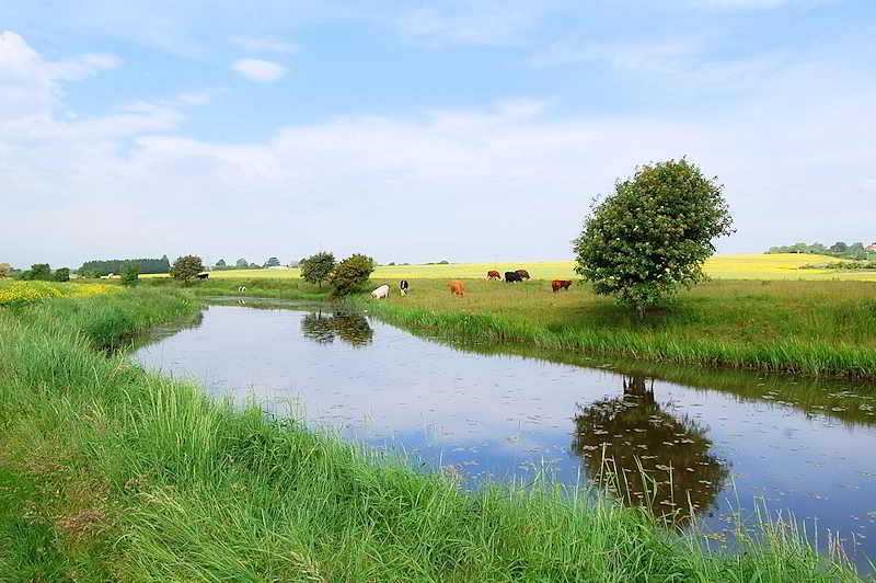
Today, the canal is an important environmental site.
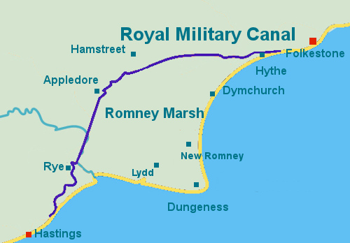
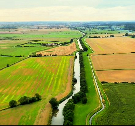
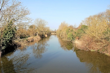
The canal runs for 28 miles from Seabrook nr Hythe through Romney Marsh to Cliff End nr Hastings in East Sussex. After Hadrian's Wall and Offa's Dyke, it is the third-longest defensive structure in the UK
Although this ancient monument no longer serves as its creators had envisaged, it now forms a tranquil haven for wildlife as it threads across the Marsh. The 7km eastern section now forms the focus of Royal Military Canal habitat enhancement programme, funded by the Heritage Lottery Fund.
Route of the canal
This constantly evolving project already provided a myriad of opportunities for the whole family, who whether they choose to stay for short or long periods will soon be aware of the benefits of the project and the available information both historical and natural.
The site can easily be accessed by all forms of transport both public and private at many points along its length. The Environment Agency is the navigation authority and uses the waterway to manage water levels on Romney Marsh and Walland Marsh. It is important for fish and other wildlife and it passes through several Sites of Special Scientific Interest.
The canal won the 2014 Green Flag Award, the Award scheme that is the benchmark national standard for parks and green. First launched in 1996, the scheme recognises and rewards the best green spaces in the country
Royal Military Canal Today
The Royal Military Canal was intended not for navigation but as a water obstacle to halt the advance of Napoleon’s troops (should they elude the Royal Navy and the Martello Towers). Romney Marsh was considered to be the most likely target of a French invasion, and the canal aimed to cut off the marsh from the land beyond. 28 miles in length, and typically about 10 metres wide and 150cm deep, it was constructed over about five years, starting in 1804. Earth dug from the wide ditch was thrown up to provide a defensive parapet, and a military road ran alongside.
The canal was conceived by Lieutenant-Colonel John Brown of the Royal Staff Corps of field engineers in 1804, as the third line of defence against Napoleon, after the British Royal Navy patrolling the English Channel and the line of 74 Martello Towers built along the south coast.
Lt-Col John Brown wrote, following his survey of the south Kent coast in a report dated 19 September 1804, ‘And as the present batteries are placed at a considerable distance from each other and could make little or no resistance after the enemy had gained the beach,’
Brown suggested that to contain the enemy a canal should be built from Shorncliffe Battery passing in front of Hythe under Lympne Heights to West Hythe as the second line of defence. He wrote
'This canal or cut should be sixty feet wide at top, forty at the bottom and nine feet deep, which would always ensure seven to eight feet of water and being everywhere within musket shot of the Heights, under such circumstances it might be deemed impregnable. This would only form part of a greater plan which might be advantageously extended on the same side along the rear of Romney Marsh by Appledore to join the Rother above Boons Bridge.'
The canal showing its 'double bends' (Ack. 42)
At a meeting on 26 September 1804, the Prime Minister, William Pitt the Younger, and the Commander-in-Chief of the Forces, the Duke of York, both enthusiastically endorsed the scheme. with the support of local General Moore. John Rennie was appointed consulting engineer, and Pitt personally persuaded the local landowners to agree to the new canal.
The Royal Military Canal was constructed in two sections. The longest section starts at Hythe in Kent and ends at Iden Lock in East Sussex. The second smaller section runs from the foot of Winchelsea Hill to Cliff End. Both sections are linked by the Rivers Rother and Brede. Building started in 1804 and completed in 1809.
Navvies dug the canal, while the military built the ramparts and turfed the banks. Flooding frequently became a barrier to progress and hand pumps were used day and night to keep the trench from filling with water. Eventually, powerful steam-driven pumps were used to clear the water.
The canal has a distinctive zig zag pattern due to unique 'kinks' along its length. Located every 600 yards these sharp 'double bends' enabled the waterway to be covered by crossfire from field guns,

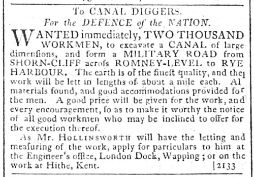
Advert for workers to dig the canal 1804
At its peak, there were 1,500 men working on the canal. The canal was dug entirely by hand, using picks and shovels and the soil was carried away in wheelbarrows. Once the canal was dug it was lined with clay. The change of command and the greater workforce speeded progress so that by August 1806 the canal was open from Seabrook to the River Rother.
It had previously been assumed that the Marsh could be flooded in the event of an invasion, but Brown argued that this would take ten days to implement and would cause massive disruption in the event of a false alarm.
At a meeting on 26 September 1804, the Prime Minister, William Pitt the Younger, and the Commander-in-Chief of the Forces, the Duke of York, both enthusiastically endorsed the scheme. John Rennie was appointed consulting engineer, and Pitt personally persuaded the local landowners to agree to the new canal.
![]() Find out more about the Royal Military Canal
Find out more about the Royal Military Canal
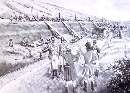
Artist's Impression of the building of the Canal
Editor's Note - Why 'Royal'?
I have been unable to definitively determine why it's called the 'Royal' Military Canal. The most likely reason is because of the canal's strong association with Prince Frederick, Duke of York and Albany, the second son of George III, The Duke of York was a soldier by profession. He became Commander-in-Chief of the British army in 1795 and embarked upon a series of reforms which revolutionised the army. He was a strong advocate for the building of the canal and, as C-C, was the person who pressed the government of the day to build it. He attended the meeting on 26 September 1804 with the Prime Minister, William Pitt the Younger where they both enthusiastically endorsed the scheme.
The Duke of York took a great interest during the building of the canal and, in 1806 when the Royal Military Canal, although not completed, was opened to the River Rother at Iden Lock, the Duke of York was in attendance, having traveled the length of th canal from Hythe to Iden. Once the canal was completed in 1809, he became one of its commissioners appointed to administer the canal.
However, the reason might be even more straightforward. The canal was the only military canal to be built in the Britain by any Government and it was built during the reign of George 111, a supporter of it being built.
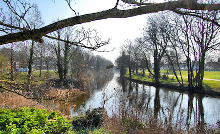
One of the most attractive walking areas on the Marsh is alongside the canal. The Royal Military Canal Path runs for 28 miles along the entire length of the Royal Military Canal from Seabrook to Cliff End. Many public footpaths link to the Royal Military Canal Path, so it is easy to plan circular routes that take in sections of the canal. For those who prefer to stay close to the water, you can walk the length of the canal in stages.
The Royal Military Canal offers a variety of cycle routes so you can chosse from a 4.2mile (7.6km), mainly of off-road ride following the banks for the tranquil canal or extend your route to 13 miles(20.9km) taking in some of the scenery of Romney Marsh.
Please see our Walking on Romney Marsh and Cycling on Romney Marsh pages for more information.
The Royal Military Canal canal has lots of wildlife, including the Marsh Frog, Emperor Dragonflies, Kingfishers and the majestic Mute Swan.
The back drains and adjacent ditches of the canal provide an ideal habitat for the endangered water vole, which requires high water levels and thick bank side vegetation to survive. The main channel of the canal is more suited to the mink - a good swimmer and a voracious predator - which was introduced to this country in the 1930s. The high, tree covered banks of the defensive parapet have provided an ideal home for badgers. As night-time approaches they can be found snuffling around, looking for earthworms, grubs and bumblebee nests
The importance of the Royal Military Canal for wildlife has led to part being designated a Site of Special Scientific Interest (SSSI), with the remaining length designated a Local Wildlife Site.
The canal is one of the best areas in Kent for coarse fishing and still has a large quantity and variety of species, with stocks of Tench, Bram, Roach and Skimmers plus excellent winter Pike fishing.
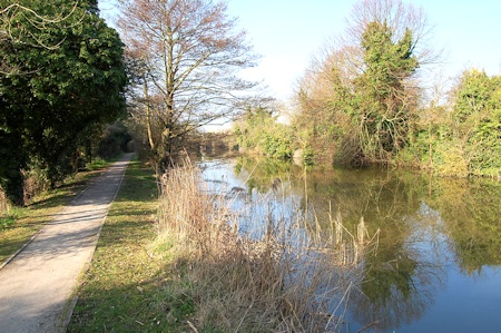
Path alongside the canal
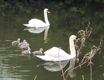
Mute Swans and their Cygnets on the canal
Certain stretches of the canal can be fished. If you want to fish at these stretches, you need to contact one of the clubs that control particular stretches of the canal.
They are:
Canal Stretch
Seabrook to Giggers Green Road contact Cinque Ports Angling Society
11 miles approx
Ruckinge to Church Lane, Kenardington
Church Lane to Appledore contact Mid Kent Fisheries
2 miles approx
It is possible to fish these stretches of the canal without being a member of the relevant clubs by obtaining a day permit.
Contact the individual fishing clubs for more information on day permit fishing and how to obtain one.
Excellent fishing
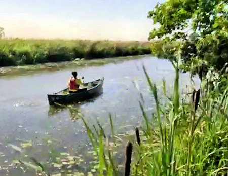
The Royal Military Canal was never intended for navigation, being primarily a defensive structure. However, in a bid to raise much needed money from the enterprise the canal was opened for public use and tolls were charged. The canal was mainly used by barges carrying shingle and other cargoes, although there was a regular passenger service which ran from Hythe to Rye. The canal remained steadily busy until the Ashford to Hastings railway was opened in 1851 - this took away most of the traffic. Barges continued to use the canal sporadically until the last toll-paying barge travelled through Iden Lock in December 1909.
Pleasure Boating
From very early on in the canal’s history, the officers stationed at Hythe used the canal for sculling and for taking their families for a row on Sundays. Once the threat of invasion had passed, local inhabitants were permitted to row on the canal. The desire to take boats on the canal has never abated with a particular peak in the 1880s when the ornamental gardens along the canal in Hythe had matured.
Today, you can hire boats to row along the canal as far as West Hythe Dam from near Ladies’ Walk Bridge in Hythe.
Boating (Ack.42)
Taking boats on the canal
It is possible to take non-powered vessels on the Royal Military Canal from Seabrook to Iden Lock. The River Rother, which is part of the canal complex, has a public right of navigation. Unfortunately it is not possible to go all the way from Seabrook to Iden Lock unhindered: boats cannot be taken through West Hythe Dam or Iden Lock, and the size of the boat will be restricted by the height of the bridges. To use your own boat or canoe on the canal you must have a licence and have public liability insurance.
To obtain a licence for the Royal Military Canal between Seabrook and West Hythe Dam or for more information on rowing this section, pleas go to the Folkestone & Hythe District Council website.
You do not need a license for the Royal Military Canal between West Hythe Dam and Iden Lock. (see here)
Information courtesy of the Romney Marsh Countryside Partnership

