
Invasion Coast Walk
The closeness of Romney Marsh to the continent, its flat shores and hinterland and easily accessible beaches, has meant that the Marsh has been in the front line whenever invasion has threatened, particularly from across the English Channel. Invaders from the Romans legions, the Anglo-Saxons, the Vikings and the French all tried. Over the centuries, the biggest threat of invasion has been from France in 1804/5 and Germany in 1940 probably coming next closest.
This page provides information about a walk along part of this Invasion Coast, to view many of the defensive historical sites and structures that helped to defend this part of the Kent coast.
The walk is also avaiable as an A5 Booklet; if you would like a copy, please conatct Peter ![]() email.
email.
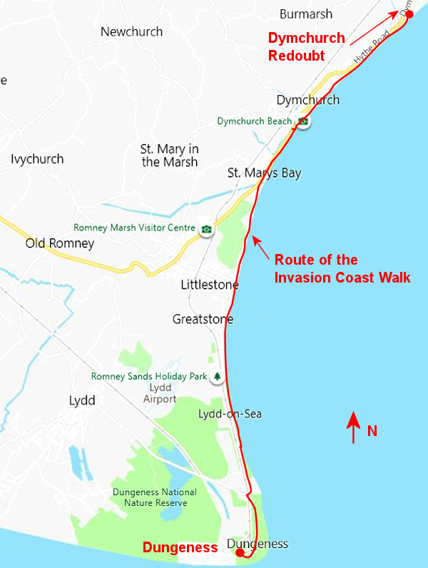
The coastline of Romney Marsh extends from Hythe round Dungeness Point, some 20 miles of coastline and includes sand dunes, sandy and shingle beaches, with much of it within the Dungeness National Nature Reserve. Almost the entire coastline is protected by concrete wall and shingle sea defences.
The Invasion Coast Walk follows part of the English Coast Path from the Dymchurch Redoubt, between Hythe and Dymchurch, and ending at Dungeness, some 12 miles away to the south.
The Invasion Coast
Walk is also available
as an A5 booklet
Please
Peter for more information


RH&DR
Old Lighthouse
Dungeness Redoubt
RNSSS Cottages
Dungeness Battery No.1
Section 2 Lydd-on-Sea to Greatstone Section 3 Greatstone to St Mary's Bay
Dungeness Battery No.2
.jpg)
Sound Mirrors
PLUTO Bungalows
Mulberry Harbour
Water Tower
Section 4 Dymchurch
Martello Tower No.25
Martello Tower No.24
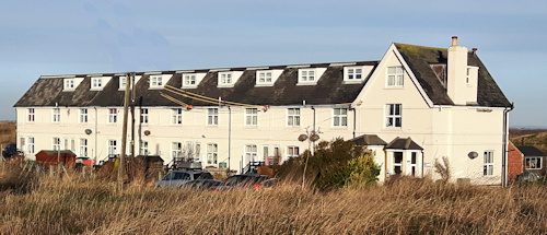
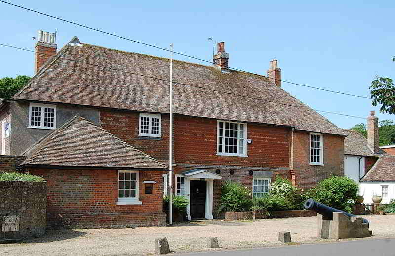
New Hall
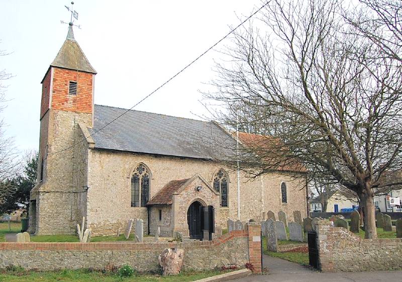
St Peter & St Paul Church
Martello Tower No.23
Section 5
We have divided the walk into five sections, to help if you would like to start and end your walk at any point along the route. The total length of the walk is about 12¾ miles. Details of each section are given below, with Section 1 starting at the southernmost point at Dungeness and Section 5 ending at Dymchurch Redoubt.
Road Travel
There are car parks adjacent to the walk at Dymchurch, St Mary's Bay, LIttlestone, Greatstone, Lydd-on-Sea and Dungeness.
See Parking - Car and Coach
Bus Travel
Bus route 102 runs on the A259, which is alongside most of the walk, as far as Lydd-on-Sea in the south.
See Bus Travel.
Train Travel
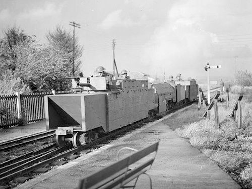
The coastal area of the Marsh from Hythe to Dungeness is served by the light railway Romney, Hythe and Dymchurch Railway (RH&DR), with stations at Hythe, Dymchurch, St Mary's Bay, Romney Warren, New Romney, Romney Sands, and Dungeness.
See RH&DR
A convenient midway point could be the car park at Coast Drive, Greatstone. Ths large car park is approximately 6.5 miles south of Dymchurch Redoubt and 5.5 miles north of Dungeness, postcode TN28 8NR.
Dogs
For the most part of the walk, it is advisable, and sometimes necessary, to keep your dog on a lead. However, they are a few places where you can walk your dog off the lead. Find out more
On this section of the walk, you will see the Old Lighthouse, the RH&DR, Dymchurch Redoubt, the RNSSS Cottages, and Dungeness Battery No.1.
This section is about 3 miles.
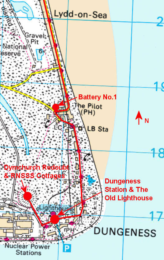
Your start point is the ![]() car park by the Dungeness Station on the RH&D Railway.
car park by the Dungeness Station on the RH&D Railway.
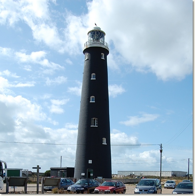
From the car park, you can see the Old Lighthouse to the south and Dungeness Redoubt and the RNSSS cottages to the north west, which are just a short walk away.
The Old Lighthouse at Dungeness offers unique and perfect views over the 500 cuspate shingle ridges, created primarily by longshore drift, that have formed the foreland, one of the largest in the world and the greatest example in the UK. It is a historic Grade II building and survived two world wars before decommission in 1960. For 56 years it provided a welcome landlight to vessels negotiating the perils of the English Channel.
Find out more
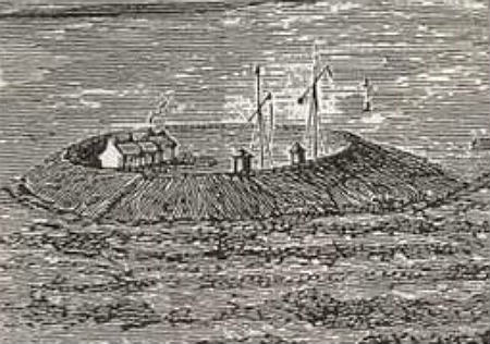
The earthwork Dungeness Redoubt was built in 1798, an octagonal strongpoint built to support the four batteries built at Dungeness.
The Redoubt was about 215 metres in diameter and originally armed with eight 24-pounders mounted around the top of the ramparts (although another source states eleven).
Find out more
The raised earthworks can still be clearly seen, with a row of ex RNSSS cottages now built inside. These 11 cottages were built to house the Royal Naval personnel who manned the Royal Naval Shore Signal Service station on Dungeness Point, next to the Old Lighthouse. The largest cottage no. 11 was for the Commanding Officer and is now used as a residential bird observatory but most of the other 10 are home to an assortment of families.
They are now they are owned by French electricity firm EDF Energy and leased via a property company. Each house has three bedrooms.
From Dungeness Station, follow the road to the north to depart from Dungeness. The road takes you through the Dungeness Estate where you will see much of the shingle landscape, and many interesting and historic properties. Join the main road from Lydd to Lydd-on-Sea, turning right into Battery Road.
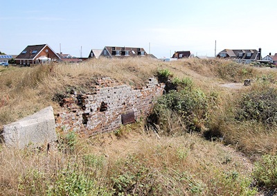
On the left, you will see a small hillock back from the road, which are the remains of Dungeness Battery No.1. This was one of four batteries built, two to the west of Dungeness Point and two to the east. These batteries were supported by a redoubt at Dungeness Point.
Find out more
On this section of the walk, you will see Dungeness Battery No. 2 (Lade Fort), the PLUTO Bungalows and the Sound Mirrors.
This section is about 3 miles.
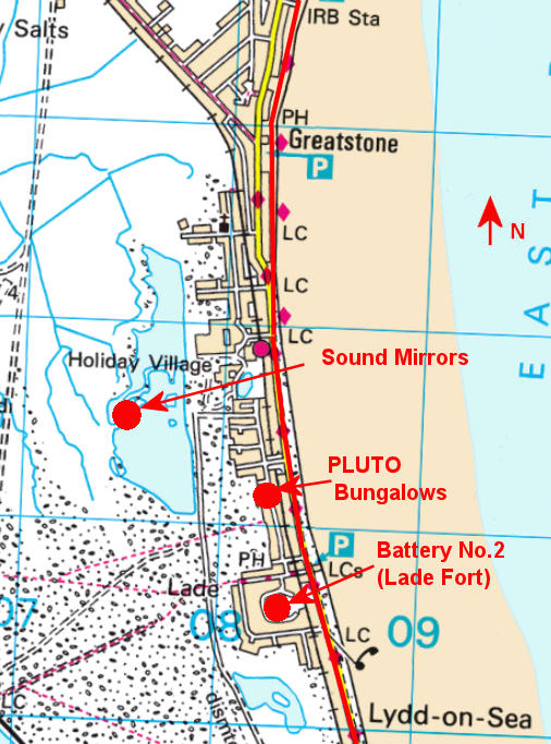
Follow the road round to the left, passing the Pilot in on your right and into Coast Drive, with the shingle and sea on your right. Continue along Coast Drive for about 1½ miles, passing Kerton Road and Williamson Road on your left. Just past Williamson Road, on the left you will see Dungeness Battery No.2 (Lade Fort). You can get closer access to the Battery by going down Taylor Road, a bit further on, on the left, and then turning left into Lade Fort Crescent.
Built in 1798, No.2 Battery/Lade Fort was a brick-built
self-contained fort on a small scale. The top platform, slightly raised to give command of the sea, accommodated 4 or 5 24-pounders, and a brick loop-holed wall 3.5 metres high extended from the corners to form a sharp point at the rear.
Find out more
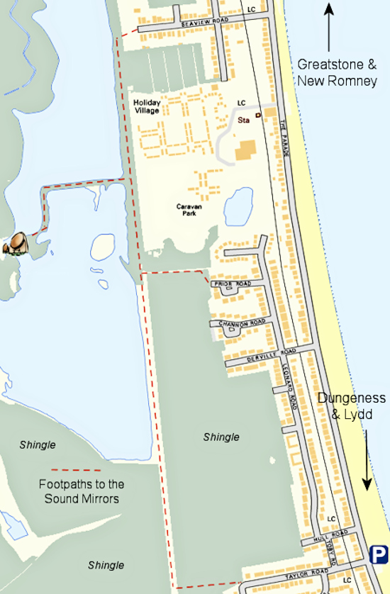
If you continue down Taylor Road to the end and look towards the north-west, you will see the Sound Mirrors. There is a footpath sign to the Mirrors here or you can wait until you are further along the coast for closer access.
Return down Taylor Road to Coast Drive, and turn left to continue walking to northwards. NB After a short distance, the road name changes to the Parade. After about ¼ mile, turn left down Derville Road and then left into Leonard Road. Walk down a little way and you will see the three PLUTO Bungalows.
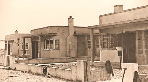
Operation PLUTO (Pipe-Line Under The Ocean or Pipe-Line Underwater Transport 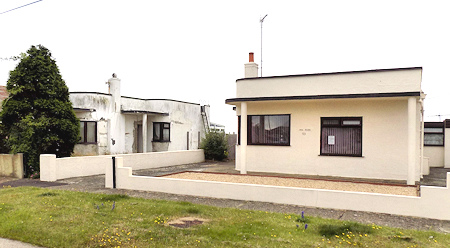 of Oil) was a Second World War operation to construct undersea oil pipelines under the English Channel between England and France in support the Allied invasion of Normandy in June 1944. To protect both the pipeline and the necessary pumping stations, all installations were disguised to prevent the Germans from identifying their proper use.
Terminals and pumping stations in Dungeness and Greatstone were disguised as bungalows, gravel pits, garages and even an ice cream shop. Three such bungalows still exist as now normal residential properties in Leonard Road.
Find out more
Once you have seen the PLUTO Bungalows, turn round and retrace your steps in Leonard Road, continuing down this road, passing Derville Road on your right, until you reach Prior Road on your left. Turn into Prior Road and continue to the end where you will come into Dungeness Nature Reserve. Bear to the right - northwest - and make your way across the reserve until you meet a well-defined footpath running south and north, with Greatstone Lakes opposite and a view of the Sound Mirrors. Turn right and follow the footpath, bearing right - westward - along the shingle trail between the south and north lakes. Continue along this trail, bearing left until you reach the swing bridge with all three of the Sound Mirrors in view. See footpaths marked in red on ![]() this map.
this map.
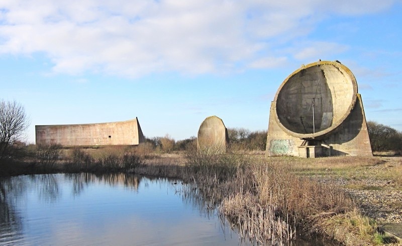
The Sound Mirrors, also known as Acoustic Mirrors, Concrete Dishes or Listening Ears, are large concrete structures, built in the late 1920s and early 1930s, designed as an early warning system for Britain to detect enemy aircraft.
These worked by focusing the sound from the plane’s engine so it could be heard before it was visible. There were three designs of mirrors, 20ft, 30ft and 200ft, and all three can be seen in Greatstone, located in the northeast side of the Dungeness Nature Reserve.
Find out more
Once you have viewed the Sound Mirrors, retrace your steps along the shingle path, into Prior Road, then Leonard Road and Derville Road until you are back in The Parade. ![]() See map. Turn left - northwards - and continue along The Parade until you come to the Holiday Park on your right.
See map. Turn left - northwards - and continue along The Parade until you come to the Holiday Park on your right.
Here you have a choice; you can either continue along The Parade or cross the road onto the beach and or Greatstone Dunes.
NB Please take care if there is a high tide - see Tides
Whatever you choose, continue walking northwards. If you continue on along the road, you will pass The Jolly Fisherman pub on your left, when the road name changes back to Coast Drive again. After about ½ mile after the pub, turn right into Coast Drive car park and onto Littlestone Greens. You will arrive at the same location by taking the beach/dunes route.
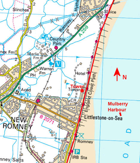
On this section of the walk, you will see the Mulberry Harbour, the Water Tower and the start of the Dymchurch Wall.
This section is about 2¼ miles.
From the car park entrance, with the sea on your right, enter the large green area (Littlestone Greens), walk past the children's play areas and continue until you meet up with the start of the sea wall, which you can follow all the way through to Dymchurch Redoubt.
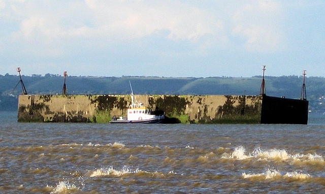
If you look ou the sea at this point, you will see part of the Mulberry Harbour. A Mulberry harbour was a portable temporary harbour developed by the British in the Second World War to facilitate rapid offloading of cargo onto the beaches during the Allied invasion of Normandy.
The harbour was built in 1943-4 from Phoenix caissons, floatable breakwater components which effectively created a mobile port facility, designed to sink or float as necessary. Two prefabricated or artificial military harbours were taken in sections across the English Channel from Britain with the invading army and assembled off the coast of Normandy.
As part of the D-Day invasion of France in 1944, and they were used by the Allies to land troops and arms at Normandy as part of Operation Overlord.
Part of one of the harbours is visible at low tide off Littlestone. It survives remarkably intact and is now an Ancient Scheduled Monument.
Find out more
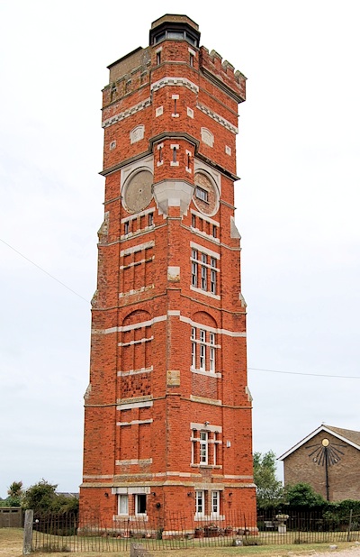
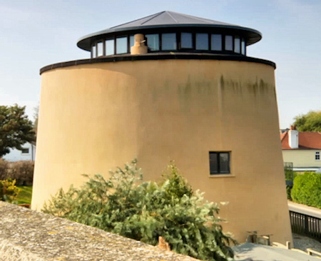
About ½ mile further on your left-hand side you will see a 120ft tower.
This tower was built as a water tower in 1890 by Henry Tubbs to supply water to his properties in Littlestone. The military used the Tower during World War Two as a lookout post and they made some changes to the structure, partly the reason for its slightly wobbly look. The Army also added a substantial concrete stairway inside. It is now a residential property
Find out more
Martello Tower 26 was built on the eastern side of the Globsden Gut Sluice, which ran into the sea near Dunstall Lane. Tower No. 27 was built approximately a quarter of a mile to the west; both were built to protect the Globsden Gut Sluice. Neither tower stands today. Damaged by sea erosion, No. 27 was demolished in 1841 and No. 26 lasted until 1871.
The site of Tower 26 was on what is now the sea wall next to the car park opposite Dunstall Lane, roughly in front of where the toilet block now stands.
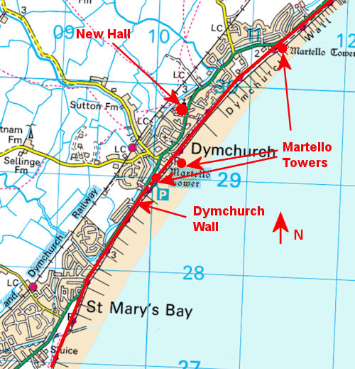
On this section of the walk, you will see 3 Martello Towers, New Hall and St Peter & St Paul Church.
This section is about 3 miles.
Continue along the sea wall, with the village of St Mary's Bay on your right until you reach the outskirts of Dymchurch.
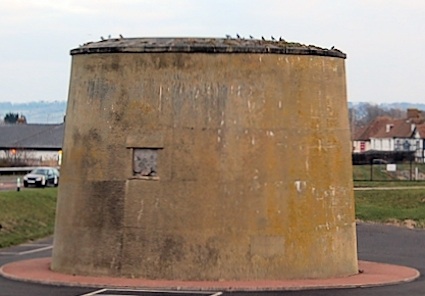
Here you will see the first of the three remaining Martello Towers in Dymchurch,
Martello Tower No. 25. This tower is owned privately, empty, in a poor state inside and awaiting development.
Find out more
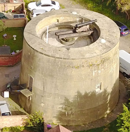
Another 5 mins walk along the sea wall brings you to Martello Tower No.24.
Martello Tower No.24 is considered to be the best surviving example, being closest to its original condition and it can be seen as it was when occupied by the military in 1806. The tower has been restored to its original design and layout with almost all of the original tower still in place and is only one of 3 of the 74 built on the south coast that is open to the public.
The tower contains almost all of the features of the original design including brickwork, front and parapet doors, window openings, fireplaces, ventilation shafts, the original 24 pounder muzzle-loading cannon on the gun platform, parapet shot lockers, hauling rings, replica gunpowder barrels, and replica 'Brown Bess' muskets.
Find our more
Once past Martello24, continue along the sea wall for about ¼ mile until you reach an exit on the left from the sea wall, marked 48A. Take this exit, walk across the small green into Sycamore Gardens, walk to the end into the main A259 road, turn left and then first right down New Hall Close. A little down on the right you will find New Hall.
The New Hall in Dymchurch dates back to the time when Dymchurch was once the headquarters for law and order on the Marsh; the name Dymchurch derives from Deme, mediaeval English for judge or arbiter.
It was here where the governors of the Marsh resided (known as The Lord of the Level), and where swift justice was administered to anyone endangering the wellbeing of the Marsh
Find out more
Opposite the New Hall there is St Peter and St Paul Church, a classic Norman church built in the 12th century about 1150 and has remained virtually unchanged for nearly 700 years.
Return to the sea wall via Sycamore Gardens, turning left (north) to continue along the sea wall for nearly a mile, where you will see the last of the Dymchurch Martello Towers, Martello Tower No.23.
Martello Tower No.23 is located on the A259 Hythe Road, just north of Dymchurch. It is now a grade II listed building and has been converted for use as a private residence. There was another Martello Tower a little further to the north but was demolished in 1956 when the A259 road was widened. Together with Tower No. 23, it was built to protect the Willop Drainage Sluice in Hythe Road.
On this section you will walk the Dymchurch Wall and end your walk at the Dymchurch Redoubt.
This section is about 1½ miles.
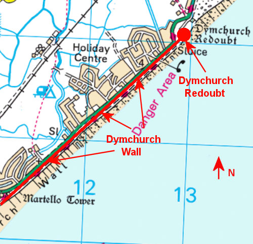
Walk past Martello Tower No.23, continuing along the sea wall.
Approximately half of the present coastline of the Romney Marsh area is defended by sea walls, the oldest of which is the Dymchurch Wall. 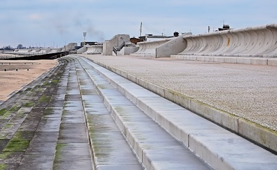 The majority of the Marsh is below mean high tide level so without the protection of the sea wall the land would be underwater much of the time.
Dymchurch has had a seawall since Roman times, with the original development being constructed to protect the harbour at Port Lympne, and then continuing throughout the centuries to help protect Romney Marsh itself.
In July 2011 a new sea wall, built at a cost of £60 million, was opened as part of the wider Folkestone to Cliff End Sea Defence Strategy, the sea defence project which will protect 2,500 properties from flooding.
Find out more
The walk from Martello Tower No.23 to Dymchurch Redoubt along the sea wall is 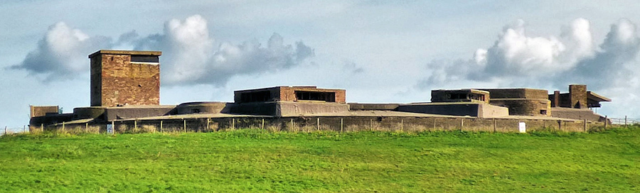 about 1½ miles, with the beach and sea to the right and residential properties and a large holiday park on the left. As you reach the end of the sea wall, you will see the large Dymchurch Redoubt to the left.
The Dymchurch Redoubt was one of three that were constructed at Harwich, Dymchurch and Eastbourne to act as supply depots for the smaller Martello Towers, as well as being powerful fortifications in their own right. The Dymchurch Redoubt was built between 1798 and 1809 to support a chain of 21 Martello Towers that stretched between Hythe in Kent and Rye in Sussex.
Find out more

