


Flood Risk on Romney Marsh
![]() Introduction
Introduction
![]() Flood Information Service
Flood Information Service
Find out whether there are Flood Warnings or Alerts for where you live,
Or use the Floodline ![]() 0345 988 1188
0345 988 1188
![]() Current Local Water Levels Data
Current Local Water Levels Data
![]() More Information
More Information
![]() Tide Times
Tide Times
![]() Defend Our Coast
Defend Our Coast
![]() Current & Future Plans
Current & Future Plans
The current situation and future plans for the various sections of the Romney Marsh coastline from the Lydd Ranges, round Dungeness Point to Hythe Ranges
![]() Deliberate Flooding of Romney Marsh
Deliberate Flooding of Romney Marsh
![]() Dymchurch Beachcam
Dymchurch Beachcam
View live pictures of the sea at Dymchurch
Flood Maps
The Environment Agency Flood Risk Map of Romney Marsh as at August 2014 is shown on the right.
For more detailed information, visit here and enter your own Post Code.
You can also view an independent Flood Map which enables you to see the approximate impact of different rises in sea level, based on data from NASA.
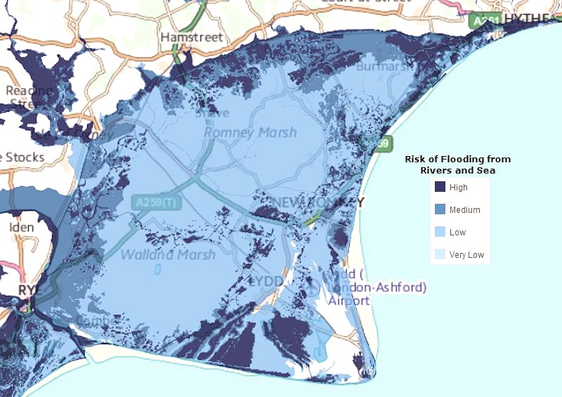
Map showing the flood risk on Romney Marsh - see a more detailed map
Effect of Climate Change
UK Climate Projections 2018 (UKCP18) Report
In November 2018 the publication of a new UK Climate Projections 2018 (UKCP18) report - a comprehensive forecast of how the climate could change over the next 100 years - has warned that sea levels could rise by between three and four feet by 2100 putting low-lying land like Romney Marsh at risk, facing near-permanent flooding.
The report said: “Sea-level rises, increased river flows and more frequent, more intense storm surges are all possible effects of climate change. This poses flooding risks to several areas of the UK.”
![]() Find out more
Find out more
UN's Intergovernmental Panel on Climate Change (IPCC) Report August 2021
The UN report on the science of climate change published in August 2021 is set to make a huge impact. The sober assessment of our planet's future has been delivered by the UN's Intergovernmental Panel on Climate Change (IPCC), a group of scientists whose findings are endorsed by the world's governments.
One key area is the continued rise in sea level. No matter what we do, the seas will continue to rise.
![]() Find out more
Find out more
The coastline and low lying land within the Romney Marsh area is one of the largest areas at risk from flooding in Southern England. Some of the areas are very vulnerable, with a 1 in 5 chance of flooding from the sea in any year.
Failure to manage the risk of coastal flooding on Romney Marsh would result in 14,000 homes and 9,603 hectares of agricultural land in danger of flooding. In addition, key infrastructure such as roads, rail links and utilities serving these assets would be lost.
The Internal Drainage Board has estimated the value of agricultural land on Romney Marsh to be £290m using land value rates.
There are a number of Environment Agency (EA) led schemes currently at the planning stage which when completed will raise the standard of protection across the Marsh in line with climate change/sea level rise predictions.
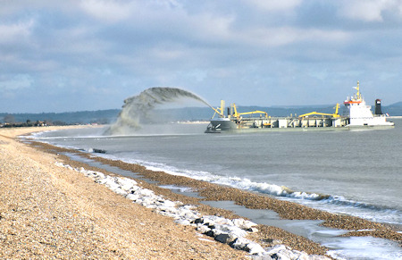
Replenishing the shingle sea defences at Litltlestone March 2016
Current Local Water Levels Data
The Environment Agency monitor the water levels in the area at their Monitoring Station at the Greatstone Pumping Station.
You can see the current data at www.riverlevels.uk.
Also:
![]() Map showing current flood risks from sea and river flooding on Romney Marsh as if there were no flood defences.
Map showing current flood risks from sea and river flooding on Romney Marsh as if there were no flood defences.
(Environment Agency April 2013)
 Watercourses on Romney Marsh
Map showing the Sea Defence and Land Drainage of Romney Marsh (1984)
![]() Environment Agency (EA) for more information about flooding, including current warnings. Just enter your postcode.
Environment Agency (EA) for more information about flooding, including current warnings. Just enter your postcode.
![]() How to prepare for flooding. Website with helpful information and advice about flooding.
How to prepare for flooding. Website with helpful information and advice about flooding.
![]() Romney Marsh - Greater Need for Emergency Planning Kent Coastal Communities 2150
Romney Marsh - Greater Need for Emergency Planning Kent Coastal Communities 2150
![]() CPRE Protect Kent and local farmers call for urgent action Press Report 9 February 2014
CPRE Protect Kent and local farmers call for urgent action Press Report 9 February 2014
![]() Community Vision and Action Plan for Romney Marsh
Community Vision and Action Plan for Romney Marsh
The 'Defend Our Coast Association' is dedicated to holding the line, to keep the sea out and defend the wider Marsh.
It has been set up by local people living on the Romney Marsh following the previous lack of community involvement by Government Agencies during sea defence policy planning, Shoreline Management Plans and consultation with local stakeholders.
The aims of Defend Our Coast are:
- To act on behalf of all local communities on the Marsh in negotiations with various Government Agencies in order to maintain and improve our existing sea defences.
- To liaise closely with all local Stakeholders, Businesses and Local Authorities to protect our communities from flooding.
- To justify to Government the continued need for sustainable communities on the Marsh and to ensure that ‘managed realignment is not an option.
- To work closely with all local communities to highlight coastal defence issues and associated effects of climate change.
- To disseminate all relevant information on sea defence issues throughout our local communities, councils and educational institutions and generally improve coastal literacy.
You can find our more at the Defend Our Coast website.
Current Situation and Future Plans
Below we look at the current situation and future plans for the various sections of the Romney Marsh Coastline.
[information is taken from a Shepway DC report dated September 2012 - updated as appropriate.]
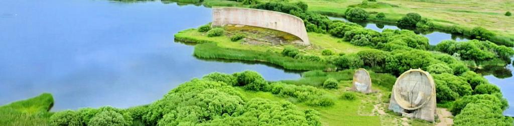
Lydd Ranges
This frontage is part of the southern shore of the Dungeness peninsula that is eroding due to a lack of sediment input from alongshore. The existing defences at Lydd Ranges comprise the shingle beaches and a secondary defence behind, consisting of an earth embankment known locally as the ‘Green Wall’. At the western end, the Green Wall is immediately behind the beach and at the eastern end is several hundred metres behind the beach. The defences have a 5% (1 in 20) to 10% (1 in 10) chance of failure in any one year where the likely failure mode would be a breach. There have been occasional breaches of the wall in past years, repaired locally with shingle from the surrounding area.
Work is due to start in April 2021 to improve the existing frontage to maintain a sea defence along the existing alignment. Once completed it will help better protect this environmentally important area and the Ministry of Defence (MoD) Lydd firing range from ongoing storm damage and coastal erosion for 25 years.
At Lydd Ranges, the existing shingle beach is being strengthened by:
- building timber groynes
- recharging the rapidly eroding beach
- stabilising the Green Wall trackway in front of the ranges
The beach is vulnerable to storm damage which has been experienced over recent winters.
Denge Marsh Sewer to Dungeness Power Stations West
A shingle ridge provides the flood defence along this frontage. This is maintained by the EA through beach profiling. A tidal flap prevents seawater from flowing along the Denge Marsh Sewer. The existing defences have a 20% (1 in 5) chance of failure in any one year, where the likely failure mode would be overtopping and breaching. This standard of protection will decrease over time if the sea level rises as predicted.
This frontage is now included within the Lydd Ranges frontage and the proposal here involves realigning the defence landward between the Denge Marsh Sewer and the Power Stations Switch House by improving the standard of protection and installing timber-clad plastic piling. This will limit the ingress of still water level flooding, whilst the shingle ridges and beach on the seaward side of the realigned defence will dissipate wave action. Realignment would improve the defences so that the risk of failure decreases to a 0.5% (1 in 200) chance in any one year up to 2108.
Dungeness Power Stations
A massive shingle embankment provides protection against a wave with a 0.01% (1 in 10,000) chance of occurring in any one year, (essentially a tsunami event). The embankment is designed to prevent the tsunami wave from breaching the defences and overwhelming the power station. Tidal flooding, e.g. from a storm surge, is not understood to be a priority as the flood warning system would allow sufficient time to shut down the station in advance of an event.
Ongoing protection here involves sustaining the current standard of defences, taking into account of predicted sea-level rise. This would meet the safety case for the power stations until 2108 and covers the power stations generating and decommissioning phases. As the stations are decommissioned, the nature and location of the hazard requiring the 1:10,000 year tsunami protection will change. There will be ongoing reviews of the flood defence needs throughout decommissioning with the management of the defences adapted accordingly.
Dungeness Shingle Recycling
The Environment Agency has been working with EDF Energy to submit a joint planning application to recycle shingle from Dungeness Point to maintain the flood defences around the power stations and along the Denge seafront.
Find out more at the Environment Agency website
Dungeness Power Stations to Greatstone
The coastline along this section is naturally accreting ie gradually increasing. At present, the shingle beach and ridges provide an appropriate standard of defence for the hinterland and there is no management intervention. ‘No active intervention’ is proposed along this frontage.
Greatstone to Romney Sands
There are sand dunes along much of this frontage that form the flood defence and provide an appropriate standard of protection. The dunes have a 0.1% (1 in 100) chance of failure in any one year, where the likely failure mode would be erosion leading to breach.
Shepway DC has responsibility for this frontage and since 2009 have successfully bid for funding to maintain the Greatstone dune system (£15k/annum). Maintenance comprises managing pedestrian traffic through the dune system by fencing to prevent erosion. The sand fencing also increases the accretion of the dunes at the base rather than the tops.
Greatstone Dunes to Littlestone South
There are no formal defences in this area and the beach provides a low standard of protection with a 2% (1 in 50) chance of failure through a breach in any one year. The frontage lies between the Greatstone Dunes in the south and Littlestone beach in the north where there is a seawall and shingle beach.
The preferred option on this frontage is for a beach recharge to raise the beach crest between the Varne Boat Club and the southern end of the sea wall at Littlestone in line with climate change/sea level rise predictions. The EA is currently in discussion with Southern Water with regard to the possibility of constructing a rock groyne around an extension to the sea outfall. It is estimated that this scheme will require an external contribution of around 75% of scheme costs in order to proceed. There are also issues around the Bathing Water Directive that may be difficult to resolve. An ‘in-situ compensatory habitat would also need to be provided should the scheme progress.
Littlestone to St Mary’s Bay
A coastal defence scheme for this frontage was completed in 2004 by the EA. The scheme comprised substantial recharge of the shingle beach, strengthening and raising of the seawall, placement of rock, construction of a new promenade and the construction of a terminal rock groyne south of the Jesson Outfall. The scheme allowed for future recycling of shingle that accretes against the terminal rock groyne, back across the frontage. The net drift rate is northerly; however, in practice the movements of shingle have been driven by a series of northeasterly sea states (i.e. the shingle is moved towards the south-west), resulting in little recent accretion at the terminal rock groyne. The defences here have a 1% (1 in 100) chance of failure in any one year, where the likely failure mode would be overtopping and erosion of the beach.
The proposed option for this frontage is to Hold the Line by continuing to maintain the current scheme for the first 50 years and then sustaining the existing defences so that risk of failure remains at 0.5% (1 in 200) chance of failure in any one year, up until 2108. The EA is considering the possibility of combining this frontage with the adjoining frontages which could prove beneficial in beach management terms.
Littlestone is to get new flood defence work in 2014/15. £1.5million has been provided to upgrade the beach defences to protect some 4,500 homes.
St Mary’s Bay
The defences along this frontage consist of extensive concrete stepped revetment, a promenade and a concrete wave return wall. The defences are in good condition, having been constructed in the mid-1990s by the EA.
The proposed option for this frontage is to Hold the Line by continuing with the existing scheme until the end of its design life (about 35 years), then by improving the existing defences. This option maintains the landscape character of the area whilst addressing the increasing flood risk over time due to climate change/sea level rise. The standard of protection would be increased so that the risk of failure is 0.5% (1 in 200) or less in any one year until 2108.
High Knocke to Dymchurch
This frontage, know as the Dymchurch Wall, is divided into two sub-sections. Frontage A begins at the north end of High Knocke and extends north for approximately 2.3km. Frontage B begins at this point and extends for approximately 2.5km to Dymchurch Redoubt. Frontage A defences comprise a raised and strengthened seawall and a stepped concrete revetment. The Frontage B defence structures are similar to those along with Frontage A, with the addition of a rock revetment along the lower part of the structure to improve wave energy dissipation. Prior to the completion of the Frontage B scheme in 2011, the existing defences had a 0% (1 in 10)chance of breach in any one year. Currently, the risk of failure is reduced to 0.5% (1 in 200) in any one year, up until 2108.
The new schemes for Frontages A and B will continue to fix the coastline in position, reducing its ability to respond to natural processes. The policy is to maintain the current standard of defence at 1 in 200 through general maintenance.
Hythe Ranges
A major coastal flood defence scheme Dymchurch and Hythe and Dymchurch to improve the defences were completed in winter 2020/21 and will reduce flood risk to 787 properties. The standard of flood protection has been improved to better protect against a flood event with a 0.5% chance of occurring in any given year.
The frontage is approximately 3.25 kilometres long between Dymchurch Redoubt in the West and Fisherman’s Beach in the east. Most of this is owned and operated by the Ministry of Defence (MoD) as a live firing range. A 150m stretch at the eastern end known as Fisherman’s Beach is owned by Folkestone and Hythe District Council.
Find out more
Prior to this scheme, the defences comprised a shingle beach with timber groynes. Rock had been placed along sections but did not form a structural revetment ie protection. These defences had a 5% (1 in 20) chance of failure in any one year through overtopping and breach.

