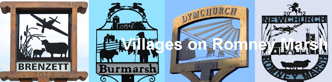
Villages on Romney Marsh


Nearby Towns and Villages
Aldington
Aldington is a village and civil parish in the Ashford District of Kent, England. The village centre is eight miles (12 km) southeast of the town of Ashford. As with the village centre, set on a steep escarpment above agricultural Romney Marsh and the upper Stour is Aldington Knoll, which was used as a Roman burial barrow and later beacon, it has a panorama towards the English Channel and of low land such as Dungeness.
Appledore
Appledore is a village and civil parish in the Ashford District of Kent, England. The village centre is on the northern edge of the Romney Marsh, 12 miles (19 km) southwest of Ashford town. The northerly part of this village is Appledore Heath.
Bilsington
Bilsington is a village and civil parish in the Ashford district of Kent, England. The village is about 5 miles (8 km) south of Ashford, on the B2067 road, Hamstreet to Hythe road north of the Royal Military Canal. About of a quarter of the parish is wooded, along most of the northern slopes leading up to the escarpment of the High Weald. The 2011 Census recorded the parish's population as 284.
Bonnington
Bonnington is a dispersed village and civil parish on the northern edge of the Romney Marsh in the Ashford District of Kent, England. The village is located eight miles (13 km) to the south of the town of Ashford on the B2067 (Hamstreet to Hythe road). Bonnington has under 100 inhabitants and has historic connections with smuggling. The parish used to boast its own school at the T-junction with the former B2069, and a public house (The Oak) located nearly two miles southeast of the village. The parish church, dedicated to St Rumwold, the child saint,[2] is about half a mile to the south of the hamlet, on the Royal Military Canal.
The parish council is now linked with the larger village of Aldington (where the population is now included) which is where the nearest shops can be found.
Camber
Camber is a village and civil parish in the Rother district of East Sussex, England, 3 miles (4.8 km) southeast of Rye. The village is located behind the sand dunes that occupy the estuary of the River Rother, where the seaside settlement of Camber Sands is situated. The village of Camber takes its name from the Camber (la Chambre) the huge embayment of the English Channel located between Rye, old Winchelsea and Old Romney that was gradually lost to "innings" and silting-up following changes to the coastline and the changed course of the Eastern Rother since the Middle Ages.
East Guldeford
East Guldeford is a village and civil parish in the Rother district of East Sussex, England. The village is located one mile (1.6 km) east of Rye on the A259 road. The parish is controlled by a parish meeting. It is in the civil parish of Playden. The parish church is dedicated to St Mary. It was consecrated in 1505.
Hamstreet
Hamstreet is a village in Kent, in South East England. The village is located 6 miles (10 km) south of Ashford on the A2070, the main road between Ashford and Hastings. The majority of the village is in the parish of Orlestone, named after a much older hamlet located 1 mile north of Hamstreet on the ridge of hills; however, part of the village falls within the parish of Warehorne, giving a total population of about 1,800 and a former claim to having three pubs (the Duke's Head is located at the village centre and there were two rural pubs within Warehorne parish). One of the pubs in Warehorne parish (the Woolpack Inn) has been renovated by the owners of the Globe Inn in Rye.
The parish church, dedicated to the Good Shepherd, is now a shared Anglican/Methodist building, and the parish churches of Orlestone, Snave (now a redundant church), Ruckinge, Warehorne and Kenardington are all within the traditional benefice which was expanded to form the new Saxon Shore benefice along with Bilsington, Bonnington and Aldington.
Hythe
Hythe is a coastal market town on the edge of Romney Marsh, in the district of Folkestone and Hythe on the south coast of Kent. The word Hythe or Hithe is an Old English word meaning haven or landing place. The town has mediaeval and Georgian buildings, as well as a Saxon/Norman church on the hill and a Victorian seafront promenade. Hythe was once defended by two castles, Saltwood and Lympne. Hythe Town Hall, a neoclassical style building, was completed in 1794.
Lympne
Lympne, formerly also Lymne, is a village on the former shallow-gradient sea cliffs above the expansive agricultural plain of Romney Marsh in Kent. The settlement forms an L shape stretching from Port Lympne Zoo via Lympne Castle facing Lympne Industrial Park then via the main settlement to Newingreen in the north, centred 11 km (7 mi) west of Folkestone, 2.3 mi (3.7 km) west of Hythe and 13 km (8.1 mi) ESE of Ashford.
Orleston
Orlestone is a mid-sized civil parish in Ashford District, Kent, England, with a population of 1,407. The centre of the parish is Hamstreet village which falls almost entirely within it but has a small fraction in the parish of Warehorne. The civil parish here reflects the very longstanding dominance of Orlestreet as its ecclesiastical parish boundary and provides a third alternative to most residents of Hamstreet to their village name, other than 'Ham Street'. Hamstreet is bypassed by the A2070 road, six miles south of Ashford.
Ruckinge
Ruckinge /rʌkɪndʒ/ is a village and civil parish in south Kent centred 5.5 miles (8.9 km) south of Ashford on the B2067 Hamstreet to Hythe road, with two settled neighbourhoods. It is, broadly defined, a narrow, fairly large rural parish of land which is about one-quarter of woodland.
Rye
Rye is a small town and civil parish in the Rother district, in East Sussex, England, two miles from the sea at the confluence of three rivers: the Rother, the Tillingham and the Brede. In medieval times, as an important member of the Cinque Ports confederation, it was at the head of an embayment of the English Channel, and almost entirely surrounded by the sea.
At the 2011 census, Rye had a population of 4,773. Its historical association with the sea has included providing ships for the service of the Crown in times of war and being involved in smuggling. The notorious Hawkhurst Gang used its ancient inns The Mermaid Inn and The Olde Bell Inn, which are said to be connected to each other by a secret passageway.
Stone in Oxney
Stone in Oxney is a village south of Ashford in Kent, South East England, in the civil parish of Stone-cum-Ebony near Appledore. The village is 11 miles (18 km) southeast of Tenterden and stands in a position on the eastern side of the Isle of Oxney. The stone that gives the village its name is preserved in the village church and is of Roman origin. Often thought to be an altar of Mithras, it in fact depicts Apis.
The Saxon Shore Way, a long-distance walking route tracing the old Saxon shoreline, passes through the parish.
Warehorne
Warehorne is a village and civil parish in the south of the Ashford Borough of Kent, England. It is a scattered community centred on the Hamstreet to Tenterden road (B2067) around seven miles SSW of Ashford. The Royal Military Canal passes through the south of the civil parish. The first recorded mention of Warehorne is in an Anglo-Saxon charter of Ecgberht, King of Wessex of 820 AD, where it is called Werehornas.
The Domesday Book of 1086 mentions Warehorne by name and states that a church existed there. The present church (St Matthews) shows no sign of Saxon or of Norman work. Warehorne was also where Reverend Richard Harris Barham, the author of The Ingoldsby Legends, resided for a short while.
West Hythe
West Hythe is a hamlet near Palmarsh in Kent, England, and a few miles west of the cinque port town of Hythe. Modern settlement is mainly on the plain south of the Royal Military Canal, and immediately north and north-west of Palmarsh, but the ancient parish church (in ruins) stands at the foot of the escarpment north of the canal, where much of the ancient village was located.
Modern development to the west of Hythe (mostly housing, together with some local shops) in a corridor along the A259 coastal road, has led to the joining together of the ancient town of Hythe and the rural hamlet of Palmarsh in a single urban conurbation, which itself reaches almost to the West Hythe community.


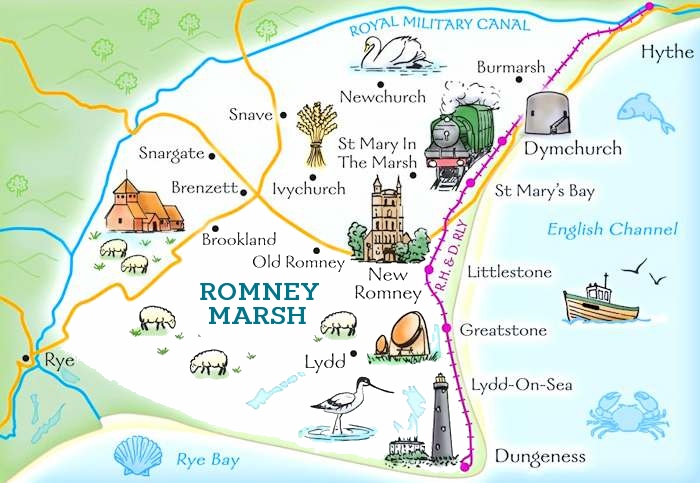
 Romney Marsh Location Map
 Red Dragon I.T. Ltd.
