Dungeness History

Dungeness is the largest cuspate foreland in Britain, and globally very unusual because it is formed predominantly of flint shingle. Cuspate forelands can be described as triangular beaches. They are formed by longshore drift moving sediment in opposing directions. The two sets of storm waves build up a series of ridges, each protecting the material behind it, creating the triangular feature. Cuspate forelands form due to the positioning of the coast and their orientation to incoming tides and prevailing winds.
The beach ridges date from about 3500 years BC and the best-preserved sequence can be traced from the 8th century AD. In addition to exposed shingle covering about 8 square miles, there are also buried shingle banks, which underlie a further 4 square miles. Other large shingle structures such as Chesil Beach in Dorest, Spey Bay in Scotland and Orfordness in Suffolk are comparable in terms of the length of coastline that they occupy, but they do not contain the enormous volume of shingle stored in the shingle ridges at Dungeness.
The feature is often regarded as an integral part of a system of former barrier beaches that extend about 25 milesfrom Fairlight in the west to Hythe in the east. Other well-known cuspate forelands, such as the Darss peninsula on the German Baltic coast, Cape Kennedy in Florida, Cabo Santa Maria on the Portuguese Algarve coast and Cabo Rojo on the Mexican coast, rival and exceed Dungeness for size, but Dungeness is unique globally because it has a number of features that are absent or less well developed elsewhere.
Dungeness Today
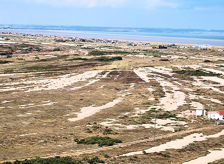
Dungeness is formed almost entirely of flint shingle and is a relatively advanced form of cuspate foreland, much of the shingle having been re-distributed from barrier beaches to form a ness, or headland, with a particularly acute angle between its two main shorelines. It has long been recognized internationally as a major example of its type.
No area, inland of beaches, to have been occupied and land-claimed over so long a period of time (about 1200 years) has been documented as intensively as Dungeness, and the documentary record extends over a far longer period than for any comparable site. Finally, in contrast to many similar features, it lacks an offshore shoal that might extend its form seawards.
It has been shown that shingle ridges often extend many hundreds of metres beyond the area of exposed shingle, the Beach Bank soil series representing the distal parts of successive beach ridges. Parts of the Lydd soil series also lie above shingle, while the Lydd series itself and parts of the Greatstone series are dominated by sand and loamy sand, which may be derived from sandy beaches associated with the shingle beaches in much the same way as sandy beaches are found today on the eastern shoreline of Dungeness.
Description
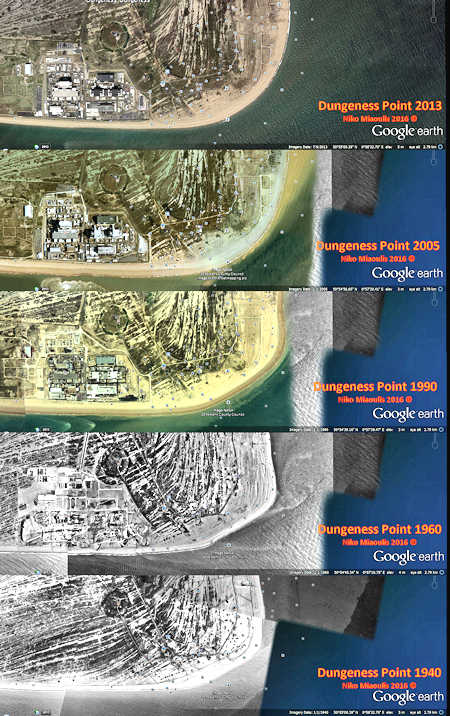
The present-day shoreline at Dungeness is formed by a southern beach that faces SSW and is gradually moving north and inland over older relict beach ridges; the acute bend of the ness itself, which is migrating SSE, and an eastern beach, which has gradually migrated eastwards as the ness has grown. Much of this eastern beach is fronted by a wide intertidal sand beach. Landward of the present-day beach, there is a sequence of buried and exposed shingle ridges, which become both younger and more curved towards the east. It has been suggested that peat dating from 1,000 to 2,000 years ago helps date the development of both Romney Marsh and Dungeness.
The oldest beaches, buried at Broomhill and Sandylands, have been tentatively dated between 5500 and 4000 years ago Between Jury's Gap and Dungeness itself, about 500 individual ridges form four main groups, Jury's Gap beach, the Forelands, Holmstone and West Ripe–Wickmaryholm with a change in ridge alignment of about 10° towards the north-west between each group.
Eastwards of Galloway's Lookout, the ridges become more curved and preserve earlier ness forms. At their seaward (southern) edge, the ridges are truncated by a single continuous ridge that forms the present-day shoreline. Inland, many of these curved ridges are buried, but represented by the Beach Bank soil series, which is described as associated with ‘old inland pebble banks and beaches'. The mapped distribution of these old beaches portrays them as having relatively straight seaward boundaries, whereas their landward edges are marked by lateral features at angles of between 30° and 40° to the main ridges, probably representing recurves in the distal part of the beaches.
Only in the area around Open Pits are distal recurves completely preserved in the bare shingle. To the north of the Open Pits and the present-day ness, the shingle is found in over 100 sub-parallel south–north-trending ridges that extend northwards to very short, buried, distal forms. Although parts of this area have been disturbed by gravel extraction, the undisturbed parts remain the finest example of a gravel strand plain on the coastline of Britain and have few rivals elsewhere in Europe.
Dungeness is a private estate. Originally owned by the Tufton family, the land which the Dungeness Estate now occupies was sold to the Southern Eastern Railway, later part of British Railways, who operated a branch line to Dungeness. This line closed to passengers in 1937 and to all traffic in 1967, a part of it remaining to serve the Power Stations. British Rail later sold it to a Mr G T Paine and remained in the Paine family trust until 2015, when it was sold to EDF energy, who run Dungeness B, a nuclear power station
Apart from lighthouse dwellings, old coastguard cottages and lifeboat stations, development of a settlement of any significance only began after the First World War when workers employed by Southern Railway purchased old carriages and set them up as beach houses or, where necessity dictated,began to adapt and extend them as homes, at the southern end of the area. Prior to this some houses had been erected, mainly at the northern end, from the late C19 to house the family who provided fresh water to passing ships, and from the beginning of the C20 for the Tart and Oiler fishing families, allegedly the first beach house residents.
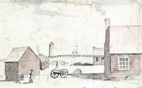
Dungeness in 1794 showing the third lighthouse and military barracks
It is likely that the single paved road off which most houses lie began as a track. Main services, telephone, electricity and water, only arrived gradually, the water main only in 1946. There is still no mains drainage. All services are supplied by overhead lines. Up to the death of Mr Paine in 1985, beach house dwellers only had 3-month leases.
The subsequent offer of 99-year leases (finally granted in 1999) prompted Shepway Council to anticipate pressure for new development, further, uncontrolled extensions of existing dwellings and enclosure of plots. Consequently, a report recommending the designation of a Conservation Area. The Secretary of State approved the Council’s application for a permanent Article 4 Direction in March 1986.
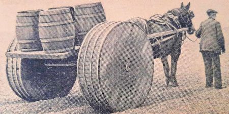
Delivering beer on the shingle on Dungeness
There is a long history of fishing from Dungeness. Up to the 1960s, boats on Dungeness were spaced out and opposite dwellings between the Pilot and the Cabin/Spion Cop. Bait digging, shrimping and fishing with nets for herring, mackerel and sprats were all practised. Pre-war, catches were dragged across the shingle in wooden boxes on runners made from wooden barrel staves. For some time pre-war, miniature guage rail tracks were installed on the beach from each boat to join a common track running between Spion Cop and the Pilot along the line of the present road. These were removed when the road was completed in 1938.
Other activities carried out on the open shingle included tanning of nets, a Springtime activity. Once the nets had been treated in tanning coppers they were spread on the beach or hung on poles to dry. This activity stopped just post-war. Also pre-war, four other boats were situated down the end of the Denge Marsh road, together with associated winch houses, a shed, lifeboat capstans and coastguard houses. Catches from these were conveyed directly to Lydd via the road. Lydd-based fishermen, operating beyond Galloways used the Galloways road. The sites were abandoned during the war, and only briefly re-used post-war.
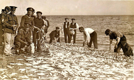
Mackerel Fishing at Dungeness c1912
The boats at Dungeness, now more in number, had moved to their present positions nearer the Ness by the 1960s. This move was, in part, a response to a pro-grading shoreline. Some people remember when the shore was much closer to the dwellings, and are therefore aware of pro-gradation.
A long abandoned branch line in Kent served Dungeness from 1883 to 1953. Opened in 1883 by The Lydd Railway Company, it closed to passengers in 1937.
Dungeness was the terminus of the Lydd Railway Company's branch from Appledore which opened on 7 December 1881. Passenger services initially terminated at Lydd, although a goods service operated as far as Dungeness. The line was opened throughout to passengers as from 1 April 1883.
The railway terminated almost at the foot of Dungeness Old Lighthouse where very basic facilities were provided in the shape of a single platform on which was perched a small arched roof weather-boarded shed comprising a ticket office, waiting room and ladies and gents toilets. (See picture right) A run-round loop was provided to facilitate engine reversals and a siding led to the lighthouse.
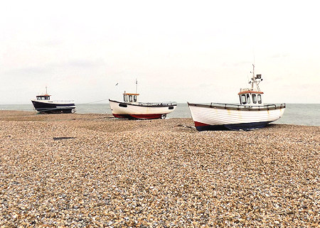
Fishing Boats Today at Dungeness
The promoters of the line had hoped that linking Dungeness, one of the largest expanses of shingle in the world, with London by rail would lead to its development as a port from which cross-channel steamers could operate to the small French fishing port of Le Tréport, 60 miles distant and 114 miles from Paris. Proposals to construct a harbour at Dungeness had been around since the 1870s and received support from South Eastern Railway chairman Edward Watkin; the inexhaustible supply of shingle could, if dug out, have been used for track ballast and to form the basin of what could have been one of the most cheaply built dock systems in the world.
The development of Dungeness failed to materialise and the South Eastern Railway, which had taken over the Lydd Railway Company in 1895, was left with a short branch lines in a remotely populated area, with the Dungeness branch carrying the lightest of traffic; shingle did provide some traffic, including flints for the Potteries which used them to provide glaze on china. The line survived for a further fifty years but finally closed to passengers in 1937, leaving it open for goods until May 1953. To make up for the closure of Dungeness, the Southern Railway opened a new station at Lydd-on-Sea (½ mile away) whose running in board read "Lydd-on-Sea (for Dungeness)".
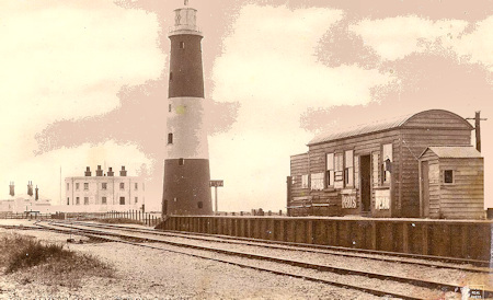
Dungeness Old Railway Station
The Northfleet was a British full rigged ship of 951 tons gross built at Northfleet, Kent in 1853 and spent much of her career trading between England and Australia and between England, India and China.
In 1873 the Northfleet was on route from Gravesend in Kent to Tasmania with a cargo of equipment to build a railway and 379 persons on board: the pilot, 34 crew, three cabin passengers and the assisted emigrants comprising 248 men, 42 women and 52 children.
Bad weather forced the ship to drop anchor at several points before leaving the Channel and on the night of 22 January she was at anchor about two or three miles (5 km) off Dungeness. Around 10.30 p.m. she was run down by a steamer that backed off and disappeared into the darkness.
The heavily-laden Northfleet sank within half an hour, before vessels in the vicinity realised anything was amiss, and in the ensuing panic a total of 293 people were drowned. 86 were saved.
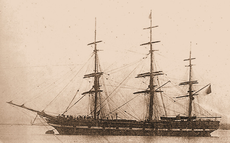
The Northfleet
Of the women onboard only the captain's wife and one emigrant survived, along with just two of the children. Only two boats managed to get clear of the sinking ship, one without any oars and the other damaged. The captain, Captain Knowles, went down with his ship.
The offending steamer proved to be the Spanish steamship Murillo, which was stopped off Dover on 22 September 1873, eight months after the collision. A Court of Admiralty condemned her to be sold and severely censured her officers.
The window in the south wall of the chapel of St Nicholas Church in New Romney commemorates the crew and passengers who died. Angel trumpeters are shown calling them up to heaven out of the waves.
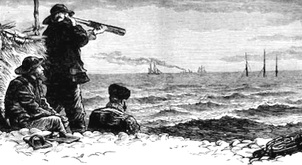
The Northfleet Disaster 1873
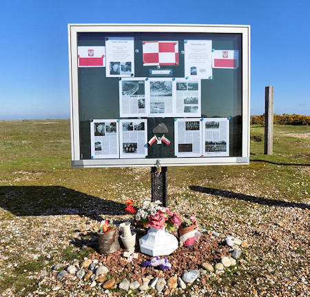
In one of the bleakest areas of Dungeness there is a memorial to two Polish Spitfire pilots killed in the Second World War on 16 April 1941.
The death of two Polish pilots, flying Spitfires in 1941: one, Pilot Officer Boguslaw Mierzwa of 303, ‘Kościuszko’ Polish Squadron RAF Northolt, crashed near the site and the other, Pilot Officer Mieczyslaw Waskiewicz, in the sea off of the point; neither pilot or plane has been found. Both were returning from a mission to escort six Blenheims sent to bomb a fighter airfield in France.
The memorial had originally been placed there by Lydd-on-Sea resident Colin Clayton. On the 75the anniversary of the deaths In April 2016, the original memorial was replaced by a more substantial structure and wooden bench, courtesy of EDF Energy and the Polish workers at the power station site.
